You are here: Home > Network List > II - Global Seismograph Network (GSN - IRIS/IDA) Stations List
> Station KAPI Kappang, Sulawesi, Indonesia > Earthquake Result Viewer
KAPI Kappang, Sulawesi, Indonesia - Earthquake Result Viewer
*The percent match for this event was below the threshold and hence no stack was calculated.
| Earthquake location: |
Southeast Of Loyalty Islands |
| Earthquake latitude/longitude: |
-22.4/171.3 |
| Earthquake time(UTC): |
2008/11/23 (328) 08:58:18 GMT |
| Earthquake Depth: |
40 km |
| Earthquake Magnitude: |
5.6 MW, 5.3 MS, 5.3 MB, 5.5 MW |
| Earthquake Catalog/Contributor: |
WHDF/NEIC |
|
| Network: |
II Global Seismograph Network (GSN - IRIS/IDA) |
| Station: |
KAPI Kappang, Sulawesi, Indonesia |
| Lat/Lon: |
5.01 S/119.75 E |
| Elevation: |
300 m |
|
| Distance: |
52.7 deg |
| Az: |
281.207 deg |
| Baz: |
114.354 deg |
| Ray Param: |
$rayparam |
*The percent match for this event was below the threshold and hence was not used in the summary stack. |
|
| Radial Match: |
62.64684 % |
| Radial Bump: |
400 |
| Transverse Match: |
39.115673 % |
| Transverse Bump: |
400 |
| SOD ConfigId: |
2658 |
| Insert Time: |
2010-03-01 21:27:56.471 +0000 |
| GWidth: |
2.5 |
| Max Bumps: |
400 |
| Tol: |
0.001 |
|
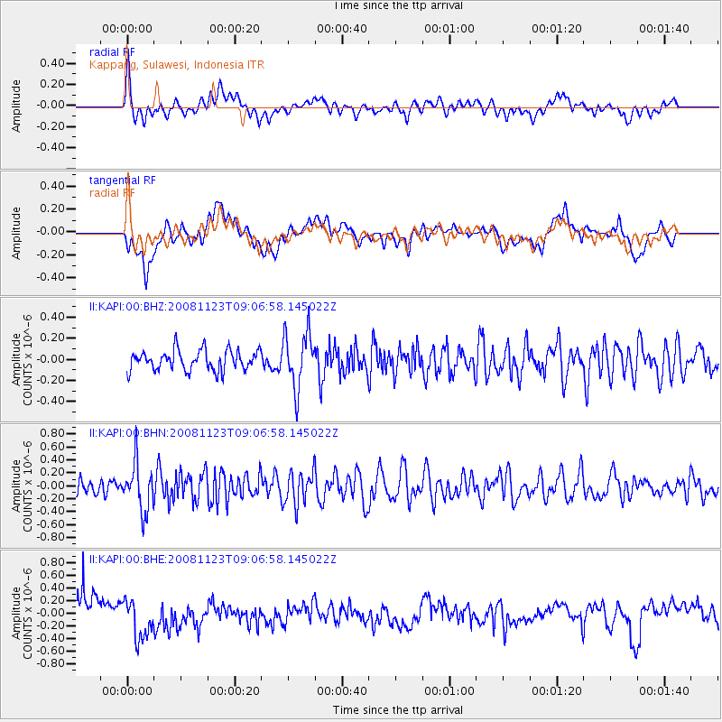
Signal To Noise
| Channel | StoN | STA | LTA |
| II:KAPI:00:BHN:20081123T09:06:58.145022Z | 3.965348 | 3.7055452E-7 | 9.344817E-8 |
| II:KAPI:00:BHE:20081123T09:06:58.145022Z | 1.866865 | 3.154786E-7 | 1.6898842E-7 |
| II:KAPI:00:BHZ:20081123T09:06:58.145022Z | 2.790776 | 2.6625403E-7 | 9.5405014E-8 |
| Arrivals |
| Ps | |
| PpPs | |
| PsPs/PpSs | |


