You are here: Home > Network List > BE - Belgian Seismic Network Stations List
> Station MEM Membach, Belgium > Earthquake Result Viewer
MEM Membach, Belgium - Earthquake Result Viewer
| Earthquake location: |
Vancouver Island, Canada Region |
| Earthquake latitude/longitude: |
49.8/-127.4 |
| Earthquake time(UTC): |
2014/04/24 (114) 03:10:13 GMT |
| Earthquake Depth: |
11 km |
| Earthquake Magnitude: |
6.7 MWP, 6.7 MI |
| Earthquake Catalog/Contributor: |
NEIC PDE/NEIC COMCAT |
|
| Network: |
BE Belgian Seismic Network |
| Station: |
MEM Membach, Belgium |
| Lat/Lon: |
50.61 N/6.01 E |
| Elevation: |
250 m |
|
| Distance: |
72.3 deg |
| Az: |
29.056 deg |
| Baz: |
330.433 deg |
| Ray Param: |
0.053743504 |
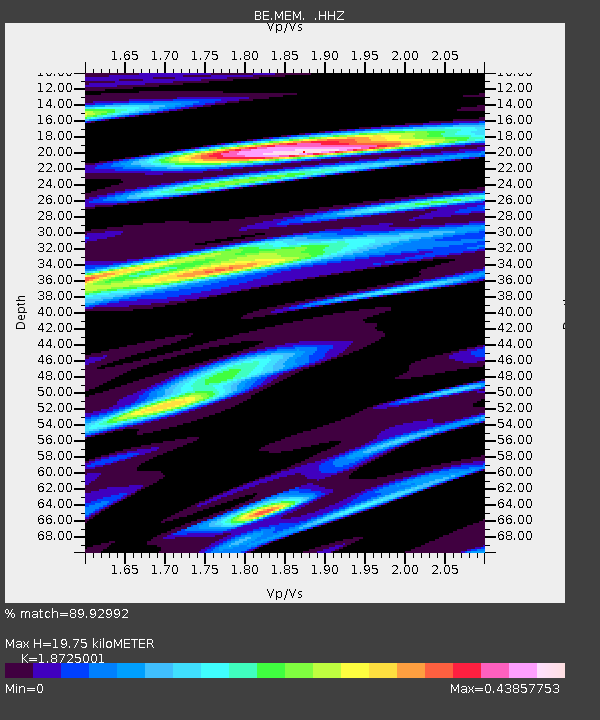
| Estimated Moho Depth: |
19.75 km |
| Estimated Crust Vp/Vs: |
1.87 |
| Assumed Crust Vp: |
6.276 km/s |
| Estimated Crust Vs: |
3.352 km/s |
| Estimated Crust Poisson's Ratio: |
0.30 |
|
| Radial Match: |
89.92992 % |
| Radial Bump: |
329 |
| Transverse Match: |
74.8647 % |
| Transverse Bump: |
354 |
| SOD ConfigId: |
626651 |
| Insert Time: |
2014-05-08 03:35:47.550 +0000 |
| GWidth: |
2.5 |
| Max Bumps: |
400 |
| Tol: |
0.001 |
|

Signal To Noise
| Channel | StoN | STA | LTA |
| BE:MEM: :HHZ:20140424T03:21:07.15801Z | 3.59216 | 6.398904E-7 | 1.7813527E-7 |
| BE:MEM: :HHN:20140424T03:21:07.15801Z | 1.6952597 | 3.0405664E-7 | 1.7935697E-7 |
| BE:MEM: :HHE:20140424T03:21:07.15801Z | 2.1970637 | 3.4411113E-7 | 1.5662319E-7 |
| Arrivals |
| Ps | 2.8 SECOND |
| PpPs | 8.8 SECOND |
| PsPs/PpSs | 12 SECOND |


