You are here: Home > Network List > II - Global Seismograph Network (GSN - IRIS/IDA) Stations List
> Station KAPI Kappang, Sulawesi, Indonesia > Earthquake Result Viewer
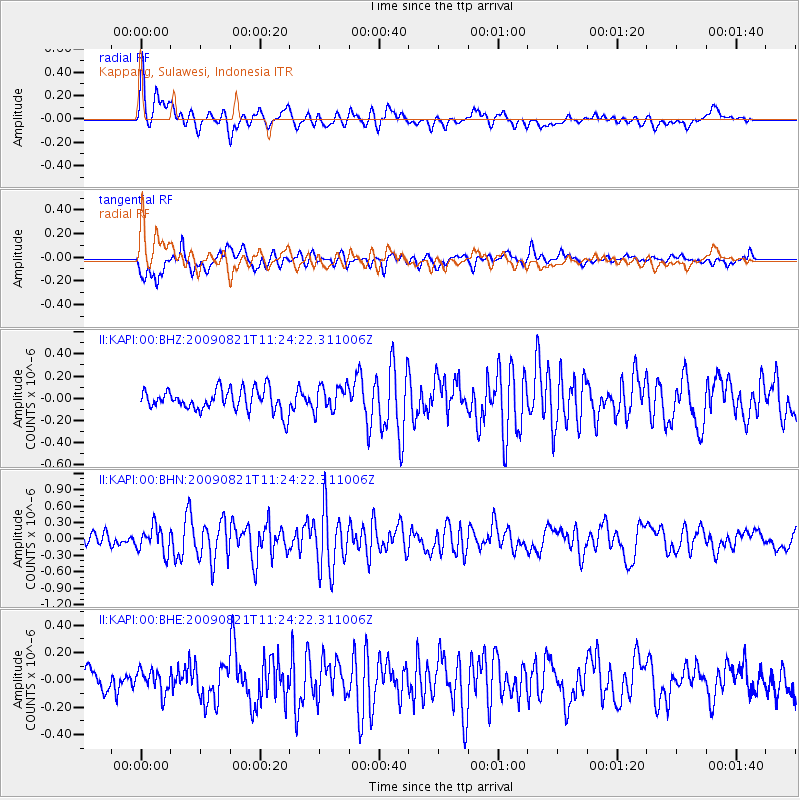
KAPI Kappang, Sulawesi, Indonesia - Earthquake Result Viewer
*The percent match for this event was below the threshold and hence no stack was calculated.
| Earthquake location: |
Southeast Of Loyalty Islands |
| Earthquake latitude/longitude: |
-22.5/171.2 |
| Earthquake time(UTC): |
2009/08/21 (233) 11:15:39 GMT |
| Earthquake Depth: |
10 km |
| Earthquake Magnitude: |
5.7 MW, 5.2 MS, 5.2 MB, 5.6 MW |
| Earthquake Catalog/Contributor: |
WHDF/NEIC |
|
| Network: |
II Global Seismograph Network (GSN - IRIS/IDA) |
| Station: |
KAPI Kappang, Sulawesi, Indonesia |
| Lat/Lon: |
5.01 S/119.75 E |
| Elevation: |
300 m |
|
| Distance: |
52.7 deg |
| Az: |
281.328 deg |
| Baz: |
114.501 deg |
| Ray Param: |
$rayparam |
*The percent match for this event was below the threshold and hence was not used in the summary stack. |
|
| Radial Match: |
67.16748 % |
| Radial Bump: |
400 |
| Transverse Match: |
70.815506 % |
| Transverse Bump: |
400 |
| SOD ConfigId: |
2622 |
| Insert Time: |
2010-03-01 21:28:08.685 +0000 |
| GWidth: |
2.5 |
| Max Bumps: |
400 |
| Tol: |
0.001 |
|
Signal To Noise
| Channel | StoN | STA | LTA |
| II:KAPI:00:BHN:20090821T11:24:22.311006Z | 2.3016946 | 2.3734938E-7 | 1.0311941E-7 |
| II:KAPI:00:BHE:20090821T11:24:22.311006Z | 0.9021447 | 8.2087546E-8 | 9.099155E-8 |
| II:KAPI:00:BHZ:20090821T11:24:22.311006Z | 1.1840711 | 1.16495876E-7 | 9.8385875E-8 |
| Arrivals |
| Ps | |
| PpPs | |
| PsPs/PpSs | |


