You are here: Home > Network List > CN - Canadian National Seismograph Network Stations List
> Station MALO MCALPINE LAKE, ON > Earthquake Result Viewer
MALO MCALPINE LAKE, ON - Earthquake Result Viewer
| Earthquake location: |
Vancouver Island, Canada Region |
| Earthquake latitude/longitude: |
49.8/-127.4 |
| Earthquake time(UTC): |
2014/04/24 (114) 03:10:13 GMT |
| Earthquake Depth: |
11 km |
| Earthquake Magnitude: |
6.7 MWP, 6.7 MI |
| Earthquake Catalog/Contributor: |
NEIC PDE/NEIC COMCAT |
|
| Network: |
CN Canadian National Seismograph Network |
| Station: |
MALO MCALPINE LAKE, ON |
| Lat/Lon: |
50.02 N/79.76 W |
| Elevation: |
271 m |
|
| Distance: |
30.3 deg |
| Az: |
71.061 deg |
| Baz: |
288.318 deg |
| Ray Param: |
0.079374924 |
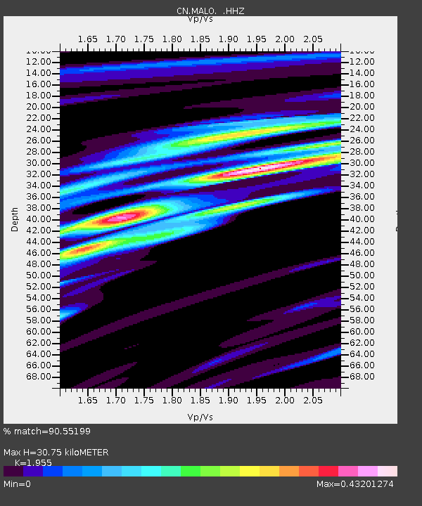
| Estimated Moho Depth: |
30.75 km |
| Estimated Crust Vp/Vs: |
1.96 |
| Assumed Crust Vp: |
6.459 km/s |
| Estimated Crust Vs: |
3.304 km/s |
| Estimated Crust Poisson's Ratio: |
0.32 |
|
| Radial Match: |
90.55199 % |
| Radial Bump: |
400 |
| Transverse Match: |
83.8914 % |
| Transverse Bump: |
350 |
| SOD ConfigId: |
626651 |
| Insert Time: |
2014-05-08 03:38:28.632 +0000 |
| GWidth: |
2.5 |
| Max Bumps: |
400 |
| Tol: |
0.001 |
|

Signal To Noise
| Channel | StoN | STA | LTA |
| CN:MALO: :HHZ:20140424T03:15:53.200002Z | 20.263107 | 1.2954116E-6 | 6.392956E-8 |
| CN:MALO: :HHN:20140424T03:15:53.200002Z | 3.5389218 | 2.1113729E-7 | 5.9661474E-8 |
| CN:MALO: :HHE:20140424T03:15:53.200002Z | 11.036184 | 7.872462E-7 | 7.133319E-8 |
| Arrivals |
| Ps | 4.9 SECOND |
| PpPs | 13 SECOND |
| PsPs/PpSs | 18 SECOND |


