You are here: Home > Network List > CI - Caltech Regional Seismic Network Stations List
> Station MPM Manuel Prospect Mine, California, USA > Earthquake Result Viewer
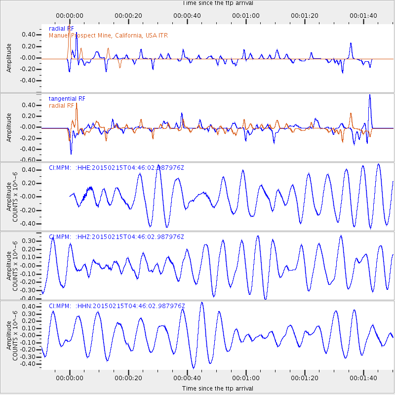
MPM Manuel Prospect Mine, California, USA - Earthquake Result Viewer
*The percent match for this event was below the threshold and hence no stack was calculated.
| Earthquake location: |
Reykjanes Ridge |
| Earthquake latitude/longitude: |
52.7/-33.5 |
| Earthquake time(UTC): |
2015/02/15 (046) 04:36:35 GMT |
| Earthquake Depth: |
10 km |
| Earthquake Magnitude: |
5.0 MW |
| Earthquake Catalog/Contributor: |
ISC/ISC |
|
| Network: |
CI Caltech Regional Seismic Network |
| Station: |
MPM Manuel Prospect Mine, California, USA |
| Lat/Lon: |
36.06 N/117.49 W |
| Elevation: |
185 m |
|
| Distance: |
58.9 deg |
| Az: |
289.72 deg |
| Baz: |
44.992 deg |
| Ray Param: |
$rayparam |
*The percent match for this event was below the threshold and hence was not used in the summary stack. |
|
| Radial Match: |
65.801315 % |
| Radial Bump: |
400 |
| Transverse Match: |
52.380817 % |
| Transverse Bump: |
400 |
| SOD ConfigId: |
7019011 |
| Insert Time: |
2019-04-16 20:04:18.877 +0000 |
| GWidth: |
2.5 |
| Max Bumps: |
400 |
| Tol: |
0.001 |
|
Signal To Noise
| Channel | StoN | STA | LTA |
| CI:MPM: :HHZ:20150215T04:46:02.987976Z | 0.44283852 | 1.2006845E-7 | 2.7113373E-7 |
| CI:MPM: :HHN:20150215T04:46:02.987976Z | 0.93078953 | 1.6831714E-7 | 1.8083266E-7 |
| CI:MPM: :HHE:20150215T04:46:02.987976Z | 2.7359173 | 3.262745E-7 | 1.1925597E-7 |
| Arrivals |
| Ps | |
| PpPs | |
| PsPs/PpSs | |


