You are here: Home > Network List > TA - USArray Transportable Network (new EarthScope stations) Stations List
> Station P57A Homestead Farm, Martinsburg, WV, USA > Earthquake Result Viewer
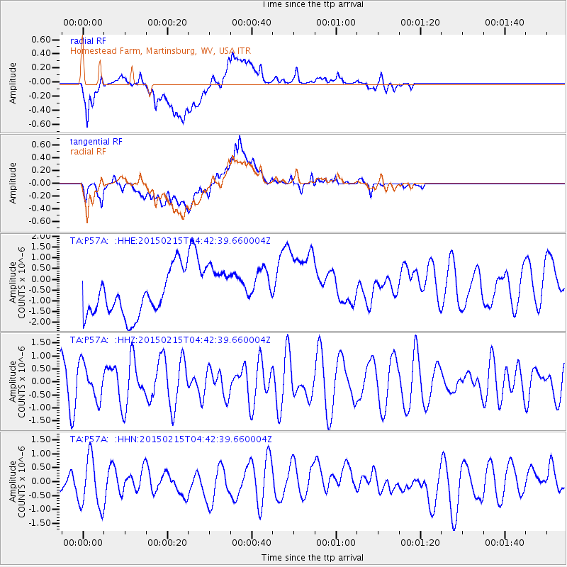
P57A Homestead Farm, Martinsburg, WV, USA - Earthquake Result Viewer
*The percent match for this event was below the threshold and hence no stack was calculated.
| Earthquake location: |
Reykjanes Ridge |
| Earthquake latitude/longitude: |
52.7/-33.5 |
| Earthquake time(UTC): |
2015/02/15 (046) 04:36:35 GMT |
| Earthquake Depth: |
10 km |
| Earthquake Magnitude: |
5.0 MW |
| Earthquake Catalog/Contributor: |
ISC/ISC |
|
| Network: |
TA USArray Transportable Network (new EarthScope stations) |
| Station: |
P57A Homestead Farm, Martinsburg, WV, USA |
| Lat/Lon: |
39.48 N/78.01 W |
| Elevation: |
191 m |
|
| Distance: |
33.0 deg |
| Az: |
264.436 deg |
| Baz: |
51.506 deg |
| Ray Param: |
$rayparam |
*The percent match for this event was below the threshold and hence was not used in the summary stack. |
|
| Radial Match: |
63.443348 % |
| Radial Bump: |
400 |
| Transverse Match: |
40.165607 % |
| Transverse Bump: |
400 |
| SOD ConfigId: |
7019011 |
| Insert Time: |
2019-04-16 20:08:51.575 +0000 |
| GWidth: |
2.5 |
| Max Bumps: |
400 |
| Tol: |
0.001 |
|
Signal To Noise
| Channel | StoN | STA | LTA |
| TA:P57A: :HHZ:20150215T04:42:39.660004Z | 1.0108314 | 6.804517E-7 | 6.7316046E-7 |
| TA:P57A: :HHN:20150215T04:42:39.660004Z | 1.8117104 | 9.629458E-7 | 5.31512E-7 |
| TA:P57A: :HHE:20150215T04:42:39.660004Z | 1.3165804 | 1.2789396E-6 | 9.714101E-7 |
| Arrivals |
| Ps | |
| PpPs | |
| PsPs/PpSs | |


