You are here: Home > Network List > LD - Lamont-Doherty Cooperative Seismographic Network Stations List
> Station LUPA Lehigh University, PA > Earthquake Result Viewer
LUPA Lehigh University, PA - Earthquake Result Viewer

| Earthquake location: |
Vancouver Island, Canada Region |
| Earthquake latitude/longitude: |
49.8/-127.4 |
| Earthquake time(UTC): |
2014/04/24 (114) 03:10:13 GMT |
| Earthquake Depth: |
11 km |
| Earthquake Magnitude: |
6.7 MWP, 6.7 MI |
| Earthquake Catalog/Contributor: |
NEIC PDE/NEIC COMCAT |
|
| Network: |
LD Lamont-Doherty Cooperative Seismographic Network |
| Station: |
LUPA Lehigh University, PA |
| Lat/Lon: |
40.60 N/75.37 W |
| Elevation: |
236 m |
|
| Distance: |
37.1 deg |
| Az: |
84.034 deg |
| Baz: |
302.268 deg |
| Ray Param: |
0.07629613 |
| Estimated Moho Depth: |
49.25 km |
| Estimated Crust Vp/Vs: |
1.67 |
| Assumed Crust Vp: |
6.283 km/s |
| Estimated Crust Vs: |
3.768 km/s |
| Estimated Crust Poisson's Ratio: |
0.22 |
|
| Radial Match: |
94.12379 % |
| Radial Bump: |
298 |
| Transverse Match: |
94.131996 % |
| Transverse Bump: |
302 |
| SOD ConfigId: |
626651 |
| Insert Time: |
2014-05-08 03:50:57.909 +0000 |
| GWidth: |
2.5 |
| Max Bumps: |
400 |
| Tol: |
0.001 |
|
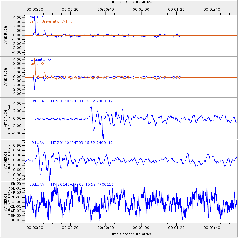
Signal To Noise
| Channel | StoN | STA | LTA |
| LD:LUPA: :HHZ:20140424T03:16:52.740011Z | 20.148043 | 4.940054E-7 | 2.451878E-8 |
| LD:LUPA: :HHN:20140424T03:16:52.740011Z | 1.3071225 | 2.7882856E-9 | 2.1331479E-9 |
| LD:LUPA: :HHE:20140424T03:16:52.740011Z | 14.852124 | 1.8546172E-6 | 1.2487217E-7 |
| Arrivals |
| Ps | 5.6 SECOND |
| PpPs | 19 SECOND |
| PsPs/PpSs | 25 SECOND |


