You are here: Home > Network List > LD - Lamont-Doherty Cooperative Seismographic Network Stations List
> Station UNH University of New Hampshire, Durham, NH, USA > Earthquake Result Viewer
UNH University of New Hampshire, Durham, NH, USA - Earthquake Result Viewer
| Earthquake location: |
Vancouver Island, Canada Region |
| Earthquake latitude/longitude: |
49.8/-127.4 |
| Earthquake time(UTC): |
2014/04/24 (114) 03:10:13 GMT |
| Earthquake Depth: |
11 km |
| Earthquake Magnitude: |
6.7 MWP, 6.7 MI |
| Earthquake Catalog/Contributor: |
NEIC PDE/NEIC COMCAT |
|
| Network: |
LD Lamont-Doherty Cooperative Seismographic Network |
| Station: |
UNH University of New Hampshire, Durham, NH, USA |
| Lat/Lon: |
43.09 N/70.87 W |
| Elevation: |
5.0 m |
|
| Distance: |
38.7 deg |
| Az: |
77.725 deg |
| Baz: |
300.286 deg |
| Ray Param: |
0.075393036 |
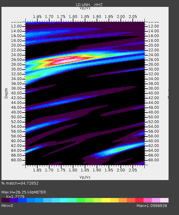
| Estimated Moho Depth: |
26.25 km |
| Estimated Crust Vp/Vs: |
1.78 |
| Assumed Crust Vp: |
6.419 km/s |
| Estimated Crust Vs: |
3.611 km/s |
| Estimated Crust Poisson's Ratio: |
0.27 |
|
| Radial Match: |
84.72852 % |
| Radial Bump: |
382 |
| Transverse Match: |
48.41009 % |
| Transverse Bump: |
400 |
| SOD ConfigId: |
626651 |
| Insert Time: |
2014-05-08 03:52:00.969 +0000 |
| GWidth: |
2.5 |
| Max Bumps: |
400 |
| Tol: |
0.001 |
|

Signal To Noise
| Channel | StoN | STA | LTA |
| LD:UNH: :HHZ:20140424T03:17:06.119985Z | 7.338836 | 3.5149228E-6 | 4.7894827E-7 |
| LD:UNH: :HHN:20140424T03:17:06.119985Z | 3.5790079 | 1.0247147E-6 | 2.8631248E-7 |
| LD:UNH: :HHE:20140424T03:17:06.119985Z | 5.729334 | 1.8120461E-6 | 3.162752E-7 |
| Arrivals |
| Ps | 3.4 SECOND |
| PpPs | 11 SECOND |
| PsPs/PpSs | 14 SECOND |


