You are here: Home > Network List > N4 - Central and EAstern US Network Stations List
> Station 060A Indiantown, FL, USA > Earthquake Result Viewer
060A Indiantown, FL, USA - Earthquake Result Viewer
| Earthquake location: |
Vancouver Island, Canada Region |
| Earthquake latitude/longitude: |
49.8/-127.4 |
| Earthquake time(UTC): |
2014/04/24 (114) 03:10:13 GMT |
| Earthquake Depth: |
11 km |
| Earthquake Magnitude: |
6.7 MWP, 6.7 MI |
| Earthquake Catalog/Contributor: |
NEIC PDE/NEIC COMCAT |
|
| Network: |
N4 Central and EAstern US Network |
| Station: |
060A Indiantown, FL, USA |
| Lat/Lon: |
27.04 N/80.36 W |
| Elevation: |
9.0 m |
|
| Distance: |
42.4 deg |
| Az: |
104.626 deg |
| Baz: |
315.392 deg |
| Ray Param: |
0.07316789 |
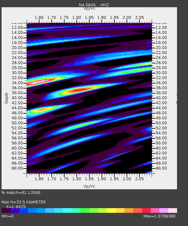
| Estimated Moho Depth: |
33.5 km |
| Estimated Crust Vp/Vs: |
1.64 |
| Assumed Crust Vp: |
6.347 km/s |
| Estimated Crust Vs: |
3.864 km/s |
| Estimated Crust Poisson's Ratio: |
0.21 |
|
| Radial Match: |
91.13588 % |
| Radial Bump: |
400 |
| Transverse Match: |
76.302315 % |
| Transverse Bump: |
400 |
| SOD ConfigId: |
626651 |
| Insert Time: |
2014-05-08 03:53:09.932 +0000 |
| GWidth: |
2.5 |
| Max Bumps: |
400 |
| Tol: |
0.001 |
|

Signal To Noise
| Channel | StoN | STA | LTA |
| N4:060A: :HHZ:20140424T03:17:36.809988Z | 16.586006 | 5.7587654E-6 | 3.4720628E-7 |
| N4:060A: :HHN:20140424T03:17:36.809988Z | 5.477898 | 2.9377895E-6 | 5.3629867E-7 |
| N4:060A: :HHE:20140424T03:17:36.809988Z | 4.6505795 | 2.5377901E-6 | 5.456933E-7 |
| Arrivals |
| Ps | 3.6 SECOND |
| PpPs | 13 SECOND |
| PsPs/PpSs | 17 SECOND |


