You are here: Home > Network List > N4 - Central and EAstern US Network Stations List
> Station 154A Montrose, GA, USA > Earthquake Result Viewer
154A Montrose, GA, USA - Earthquake Result Viewer
| Earthquake location: |
Vancouver Island, Canada Region |
| Earthquake latitude/longitude: |
49.8/-127.4 |
| Earthquake time(UTC): |
2014/04/24 (114) 03:10:13 GMT |
| Earthquake Depth: |
11 km |
| Earthquake Magnitude: |
6.7 MWP, 6.7 MI |
| Earthquake Catalog/Contributor: |
NEIC PDE/NEIC COMCAT |
|
| Network: |
N4 Central and EAstern US Network |
| Station: |
154A Montrose, GA, USA |
| Lat/Lon: |
32.61 N/83.11 W |
| Elevation: |
111 m |
|
| Distance: |
36.9 deg |
| Az: |
100.849 deg |
| Baz: |
311.12 deg |
| Ray Param: |
0.07642791 |
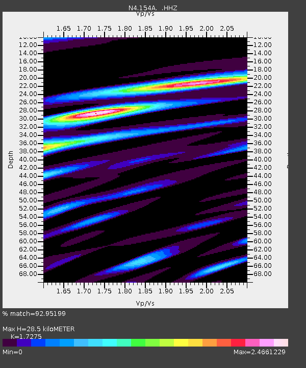
| Estimated Moho Depth: |
28.5 km |
| Estimated Crust Vp/Vs: |
1.73 |
| Assumed Crust Vp: |
6.565 km/s |
| Estimated Crust Vs: |
3.8 km/s |
| Estimated Crust Poisson's Ratio: |
0.25 |
|
| Radial Match: |
92.95199 % |
| Radial Bump: |
400 |
| Transverse Match: |
72.54061 % |
| Transverse Bump: |
400 |
| SOD ConfigId: |
626651 |
| Insert Time: |
2014-05-08 03:53:29.046 +0000 |
| GWidth: |
2.5 |
| Max Bumps: |
400 |
| Tol: |
0.001 |
|

Signal To Noise
| Channel | StoN | STA | LTA |
| N4:154A: :HHZ:20140424T03:16:50.680013Z | 35.115807 | 5.8060327E-6 | 1.6533959E-7 |
| N4:154A: :HHN:20140424T03:16:50.680013Z | 18.792662 | 4.6146E-6 | 2.455533E-7 |
| N4:154A: :HHE:20140424T03:16:50.680013Z | 13.014411 | 4.9798246E-6 | 3.8263929E-7 |
| Arrivals |
| Ps | 3.4 SECOND |
| PpPs | 11 SECOND |
| PsPs/PpSs | 14 SECOND |


