You are here: Home > Network List > NI - North-East Italy Broadband Network Stations List
> Station DRE Drenchia > Earthquake Result Viewer
DRE Drenchia - Earthquake Result Viewer
| Earthquake location: |
Vancouver Island, Canada Region |
| Earthquake latitude/longitude: |
49.8/-127.4 |
| Earthquake time(UTC): |
2014/04/24 (114) 03:10:13 GMT |
| Earthquake Depth: |
11 km |
| Earthquake Magnitude: |
6.7 MWP, 6.7 MI |
| Earthquake Catalog/Contributor: |
NEIC PDE/NEIC COMCAT |
|
| Network: |
NI North-East Italy Broadband Network |
| Station: |
DRE Drenchia |
| Lat/Lon: |
46.17 N/13.65 E |
| Elevation: |
810 m |
|
| Distance: |
78.6 deg |
| Az: |
26.455 deg |
| Baz: |
335.48 deg |
| Ray Param: |
0.04954857 |
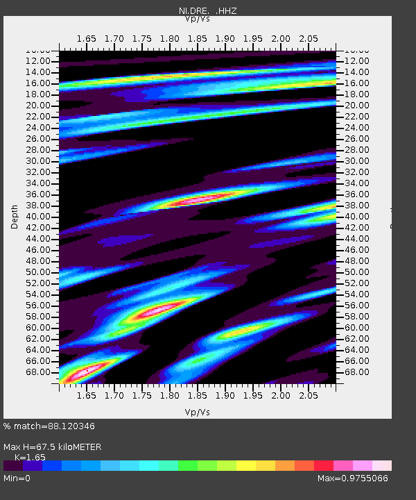
| Estimated Moho Depth: |
67.5 km |
| Estimated Crust Vp/Vs: |
1.65 |
| Assumed Crust Vp: |
6.35 km/s |
| Estimated Crust Vs: |
3.848 km/s |
| Estimated Crust Poisson's Ratio: |
0.21 |
|
| Radial Match: |
88.120346 % |
| Radial Bump: |
363 |
| Transverse Match: |
82.28255 % |
| Transverse Bump: |
400 |
| SOD ConfigId: |
626651 |
| Insert Time: |
2014-05-08 03:58:12.720 +0000 |
| GWidth: |
2.5 |
| Max Bumps: |
400 |
| Tol: |
0.001 |
|

Signal To Noise
| Channel | StoN | STA | LTA |
| NI:DRE: :HHZ:20140424T03:21:43.007986Z | 4.7654834 | 4.1349995E-7 | 8.676978E-8 |
| NI:DRE: :HHN:20140424T03:21:43.007986Z | 1.0446571 | 1.511179E-7 | 1.4465789E-7 |
| NI:DRE: :HHE:20140424T03:21:43.007986Z | 0.9953782 | 8.809264E-8 | 8.850168E-8 |
| Arrivals |
| Ps | 7.1 SECOND |
| PpPs | 27 SECOND |
| PsPs/PpSs | 34 SECOND |


