You are here: Home > Network List > NM - Cooperative New Madrid Seismic Network Stations List
> Station GNAR Gosnell,AR > Earthquake Result Viewer
GNAR Gosnell,AR - Earthquake Result Viewer
| Earthquake location: |
Vancouver Island, Canada Region |
| Earthquake latitude/longitude: |
49.8/-127.4 |
| Earthquake time(UTC): |
2014/04/24 (114) 03:10:13 GMT |
| Earthquake Depth: |
11 km |
| Earthquake Magnitude: |
6.7 MWP, 6.7 MI |
| Earthquake Catalog/Contributor: |
NEIC PDE/NEIC COMCAT |
|
| Network: |
NM Cooperative New Madrid Seismic Network |
| Station: |
GNAR Gosnell,AR |
| Lat/Lon: |
35.97 N/90.02 W |
| Elevation: |
71 m |
|
| Distance: |
30.4 deg |
| Az: |
102.876 deg |
| Baz: |
308.93 deg |
| Ray Param: |
0.07934935 |
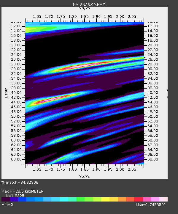
| Estimated Moho Depth: |
28.5 km |
| Estimated Crust Vp/Vs: |
1.83 |
| Assumed Crust Vp: |
6.273 km/s |
| Estimated Crust Vs: |
3.423 km/s |
| Estimated Crust Poisson's Ratio: |
0.29 |
|
| Radial Match: |
84.32366 % |
| Radial Bump: |
400 |
| Transverse Match: |
59.93811 % |
| Transverse Bump: |
400 |
| SOD ConfigId: |
626651 |
| Insert Time: |
2014-05-08 03:58:47.659 +0000 |
| GWidth: |
2.5 |
| Max Bumps: |
400 |
| Tol: |
0.001 |
|

Signal To Noise
| Channel | StoN | STA | LTA |
| NM:GNAR:00:HHZ:20140424T03:15:54.050009Z | 21.769619 | 5.036639E-6 | 2.3136091E-7 |
| NM:GNAR:00:HHN:20140424T03:15:54.050009Z | 9.85996 | 3.3724893E-6 | 3.4203885E-7 |
| NM:GNAR:00:HHE:20140424T03:15:54.050009Z | 5.2069683 | 3.9971296E-6 | 7.6765E-7 |
| Arrivals |
| Ps | 4.1 SECOND |
| PpPs | 12 SECOND |
| PsPs/PpSs | 16 SECOND |


