You are here: Home > Network List > TA - USArray Transportable Network (new EarthScope stations) Stations List
> Station D50A G1974 Best Township, ON, CAN > Earthquake Result Viewer
D50A G1974 Best Township, ON, CAN - Earthquake Result Viewer

| Earthquake location: |
Vancouver Island, Canada Region |
| Earthquake latitude/longitude: |
49.8/-127.4 |
| Earthquake time(UTC): |
2014/04/24 (114) 03:10:13 GMT |
| Earthquake Depth: |
11 km |
| Earthquake Magnitude: |
6.7 MWP, 6.7 MI |
| Earthquake Catalog/Contributor: |
NEIC PDE/NEIC COMCAT |
|
| Network: |
TA USArray Transportable Network (new EarthScope stations) |
| Station: |
D50A G1974 Best Township, ON, CAN |
| Lat/Lon: |
47.17 N/79.84 W |
| Elevation: |
331 m |
|
| Distance: |
31.2 deg |
| Az: |
76.336 deg |
| Baz: |
292.794 deg |
| Ray Param: |
0.07912356 |
| Estimated Moho Depth: |
24.75 km |
| Estimated Crust Vp/Vs: |
2.04 |
| Assumed Crust Vp: |
6.622 km/s |
| Estimated Crust Vs: |
3.254 km/s |
| Estimated Crust Poisson's Ratio: |
0.34 |
|
| Radial Match: |
94.922 % |
| Radial Bump: |
217 |
| Transverse Match: |
82.95104 % |
| Transverse Bump: |
400 |
| SOD ConfigId: |
626651 |
| Insert Time: |
2014-05-08 04:04:38.960 +0000 |
| GWidth: |
2.5 |
| Max Bumps: |
400 |
| Tol: |
0.001 |
|
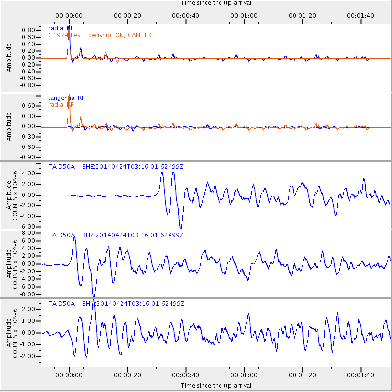
Signal To Noise
| Channel | StoN | STA | LTA |
| TA:D50A: :BHZ:20140424T03:16:01.62499Z | 25.787218 | 3.980577E-6 | 1.543624E-7 |
| TA:D50A: :BHN:20140424T03:16:01.62499Z | 9.146965 | 1.0103809E-6 | 1.10460775E-7 |
| TA:D50A: :BHE:20140424T03:16:01.62499Z | 21.429241 | 2.4062942E-6 | 1.12290216E-7 |
| Arrivals |
| Ps | 4.2 SECOND |
| PpPs | 11 SECOND |
| PsPs/PpSs | 15 SECOND |


