You are here: Home > Network List > TA - USArray Transportable Network (new EarthScope stations) Stations List
> Station D51A Lot 18 Range III Mazenod Township, QC, CAN > Earthquake Result Viewer
D51A Lot 18 Range III Mazenod Township, QC, CAN - Earthquake Result Viewer
| Earthquake location: |
Vancouver Island, Canada Region |
| Earthquake latitude/longitude: |
49.8/-127.4 |
| Earthquake time(UTC): |
2014/04/24 (114) 03:10:13 GMT |
| Earthquake Depth: |
11 km |
| Earthquake Magnitude: |
6.7 MWP, 6.7 MI |
| Earthquake Catalog/Contributor: |
NEIC PDE/NEIC COMCAT |
|
| Network: |
TA USArray Transportable Network (new EarthScope stations) |
| Station: |
D51A Lot 18 Range III Mazenod Township, QC, CAN |
| Lat/Lon: |
47.09 N/79.37 W |
| Elevation: |
282 m |
|
| Distance: |
31.5 deg |
| Az: |
76.232 deg |
| Baz: |
293.048 deg |
| Ray Param: |
0.07902694 |
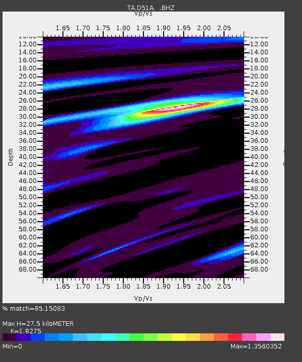
| Estimated Moho Depth: |
27.5 km |
| Estimated Crust Vp/Vs: |
1.93 |
| Assumed Crust Vp: |
6.622 km/s |
| Estimated Crust Vs: |
3.436 km/s |
| Estimated Crust Poisson's Ratio: |
0.32 |
|
| Radial Match: |
95.15083 % |
| Radial Bump: |
215 |
| Transverse Match: |
75.40162 % |
| Transverse Bump: |
400 |
| SOD ConfigId: |
626651 |
| Insert Time: |
2014-05-08 04:04:39.808 +0000 |
| GWidth: |
2.5 |
| Max Bumps: |
400 |
| Tol: |
0.001 |
|

Signal To Noise
| Channel | StoN | STA | LTA |
| TA:D51A: :BHZ:20140424T03:16:04.49999Z | 18.62928 | 4.0872187E-6 | 2.1939758E-7 |
| TA:D51A: :BHN:20140424T03:16:04.49999Z | 6.5558443 | 1.0033592E-6 | 1.5304806E-7 |
| TA:D51A: :BHE:20140424T03:16:04.49999Z | 18.000566 | 2.4390515E-6 | 1.3549861E-7 |
| Arrivals |
| Ps | 4.2 SECOND |
| PpPs | 11 SECOND |
| PsPs/PpSs | 15 SECOND |


