You are here: Home > Network List > TA - USArray Transportable Network (new EarthScope stations) Stations List
> Station D54A Lac Fusel, La Vallee-de-La-Gatineau, QC, CAN > Earthquake Result Viewer
D54A Lac Fusel, La Vallee-de-La-Gatineau, QC, CAN - Earthquake Result Viewer
| Earthquake location: |
Vancouver Island, Canada Region |
| Earthquake latitude/longitude: |
49.8/-127.4 |
| Earthquake time(UTC): |
2014/04/24 (114) 03:10:13 GMT |
| Earthquake Depth: |
11 km |
| Earthquake Magnitude: |
6.7 MWP, 6.7 MI |
| Earthquake Catalog/Contributor: |
NEIC PDE/NEIC COMCAT |
|
| Network: |
TA USArray Transportable Network (new EarthScope stations) |
| Station: |
D54A Lac Fusel, La Vallee-de-La-Gatineau, QC, CAN |
| Lat/Lon: |
47.15 N/76.66 W |
| Elevation: |
415 m |
|
| Distance: |
33.2 deg |
| Az: |
74.75 deg |
| Baz: |
293.781 deg |
| Ray Param: |
0.07830176 |
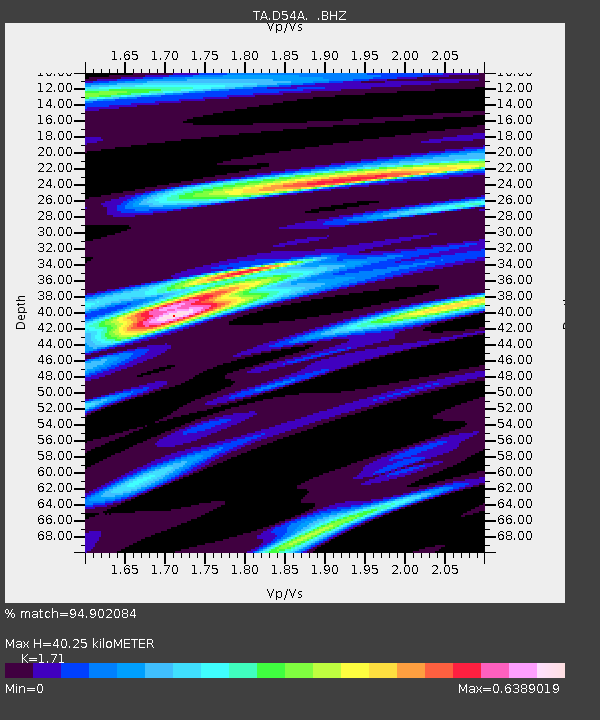
| Estimated Moho Depth: |
40.25 km |
| Estimated Crust Vp/Vs: |
1.71 |
| Assumed Crust Vp: |
6.622 km/s |
| Estimated Crust Vs: |
3.873 km/s |
| Estimated Crust Poisson's Ratio: |
0.24 |
|
| Radial Match: |
94.902084 % |
| Radial Bump: |
278 |
| Transverse Match: |
67.19448 % |
| Transverse Bump: |
400 |
| SOD ConfigId: |
626651 |
| Insert Time: |
2014-05-08 04:04:48.262 +0000 |
| GWidth: |
2.5 |
| Max Bumps: |
400 |
| Tol: |
0.001 |
|

Signal To Noise
| Channel | StoN | STA | LTA |
| TA:D54A: :BHZ:20140424T03:16:19.150015Z | 12.249888 | 3.7838208E-6 | 3.0888614E-7 |
| TA:D54A: :BHN:20140424T03:16:19.150015Z | 4.233424 | 7.6617897E-7 | 1.8098328E-7 |
| TA:D54A: :BHE:20140424T03:16:19.150015Z | 14.000492 | 2.1042802E-6 | 1.5030044E-7 |
| Arrivals |
| Ps | 4.7 SECOND |
| PpPs | 15 SECOND |
| PsPs/PpSs | 20 SECOND |


