You are here: Home > Network List > TA - USArray Transportable Network (new EarthScope stations) Stations List
> Station E53A Dumoine, Pontiac MRC, QC, CAN > Earthquake Result Viewer
E53A Dumoine, Pontiac MRC, QC, CAN - Earthquake Result Viewer

| Earthquake location: |
Vancouver Island, Canada Region |
| Earthquake latitude/longitude: |
49.8/-127.4 |
| Earthquake time(UTC): |
2014/04/24 (114) 03:10:13 GMT |
| Earthquake Depth: |
11 km |
| Earthquake Magnitude: |
6.7 MWP, 6.7 MI |
| Earthquake Catalog/Contributor: |
NEIC PDE/NEIC COMCAT |
|
| Network: |
TA USArray Transportable Network (new EarthScope stations) |
| Station: |
E53A Dumoine, Pontiac MRC, QC, CAN |
| Lat/Lon: |
46.38 N/77.66 W |
| Elevation: |
355 m |
|
| Distance: |
32.9 deg |
| Az: |
76.564 deg |
| Baz: |
294.569 deg |
| Ray Param: |
0.07844679 |
| Estimated Moho Depth: |
52.75 km |
| Estimated Crust Vp/Vs: |
1.70 |
| Assumed Crust Vp: |
6.622 km/s |
| Estimated Crust Vs: |
3.895 km/s |
| Estimated Crust Poisson's Ratio: |
0.24 |
|
| Radial Match: |
95.02181 % |
| Radial Bump: |
261 |
| Transverse Match: |
82.81532 % |
| Transverse Bump: |
400 |
| SOD ConfigId: |
626651 |
| Insert Time: |
2014-05-08 04:05:37.574 +0000 |
| GWidth: |
2.5 |
| Max Bumps: |
400 |
| Tol: |
0.001 |
|
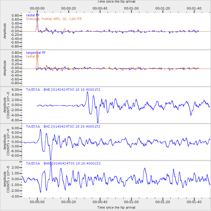
Signal To Noise
| Channel | StoN | STA | LTA |
| TA:E53A: :BHZ:20140424T03:16:16.400015Z | 27.069618 | 4.4479193E-6 | 1.6431407E-7 |
| TA:E53A: :BHN:20140424T03:16:16.400015Z | 5.6091356 | 1.1078573E-6 | 1.9750945E-7 |
| TA:E53A: :BHE:20140424T03:16:16.400015Z | 20.646507 | 2.6677926E-6 | 1.2921278E-7 |
| Arrivals |
| Ps | 6.1 SECOND |
| PpPs | 20 SECOND |
| PsPs/PpSs | 26 SECOND |


