You are here: Home > Network List > TA - USArray Transportable Network (new EarthScope stations) Stations List
> Station E56A St. Veronique, QC, CAN > Earthquake Result Viewer
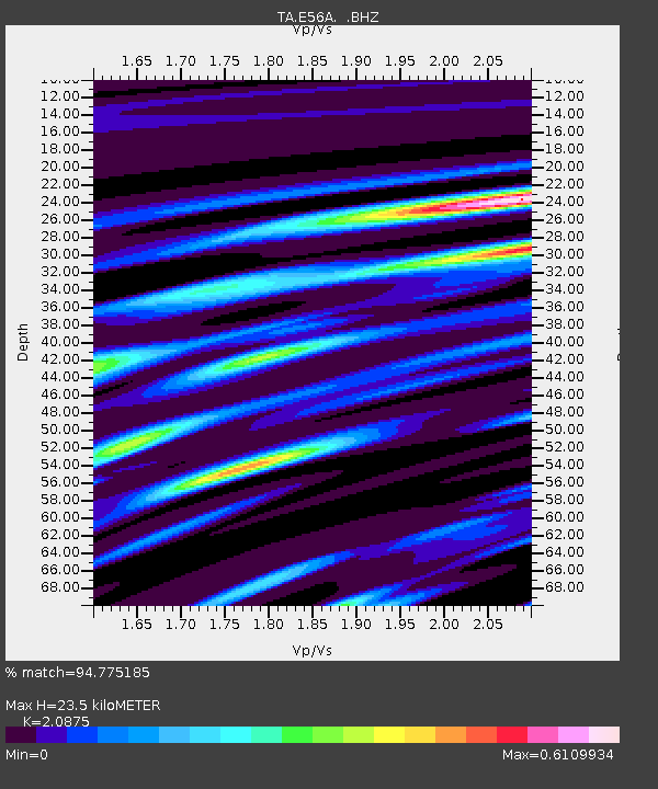
E56A St. Veronique, QC, CAN - Earthquake Result Viewer
| Earthquake location: |
Vancouver Island, Canada Region |
| Earthquake latitude/longitude: |
49.8/-127.4 |
| Earthquake time(UTC): |
2014/04/24 (114) 03:10:13 GMT |
| Earthquake Depth: |
11 km |
| Earthquake Magnitude: |
6.7 MWP, 6.7 MI |
| Earthquake Catalog/Contributor: |
NEIC PDE/NEIC COMCAT |
|
| Network: |
TA USArray Transportable Network (new EarthScope stations) |
| Station: |
E56A St. Veronique, QC, CAN |
| Lat/Lon: |
46.54 N/75.03 W |
| Elevation: |
320 m |
|
| Distance: |
34.5 deg |
| Az: |
74.917 deg |
| Baz: |
295.1 deg |
| Ray Param: |
0.07771002 |
| Estimated Moho Depth: |
23.5 km |
| Estimated Crust Vp/Vs: |
2.09 |
| Assumed Crust Vp: |
6.61 km/s |
| Estimated Crust Vs: |
3.166 km/s |
| Estimated Crust Poisson's Ratio: |
0.35 |
|
| Radial Match: |
94.775185 % |
| Radial Bump: |
314 |
| Transverse Match: |
55.692417 % |
| Transverse Bump: |
400 |
| SOD ConfigId: |
626651 |
| Insert Time: |
2014-05-08 04:05:51.735 +0000 |
| GWidth: |
2.5 |
| Max Bumps: |
400 |
| Tol: |
0.001 |
|

Signal To Noise
| Channel | StoN | STA | LTA |
| TA:E56A: :BHZ:20140424T03:16:30.12499Z | 21.193562 | 4.028176E-6 | 1.9006602E-7 |
| TA:E56A: :BHN:20140424T03:16:30.12499Z | 5.727688 | 1.477412E-6 | 2.579421E-7 |
| TA:E56A: :BHE:20140424T03:16:30.12499Z | 10.206805 | 1.917062E-6 | 1.8782195E-7 |
| Arrivals |
| Ps | 4.1 SECOND |
| PpPs | 10 SECOND |
| PsPs/PpSs | 14 SECOND |


