You are here: Home > Network List > TA - USArray Transportable Network (new EarthScope stations) Stations List
> Station E58A La Victoria, QC, CAN > Earthquake Result Viewer
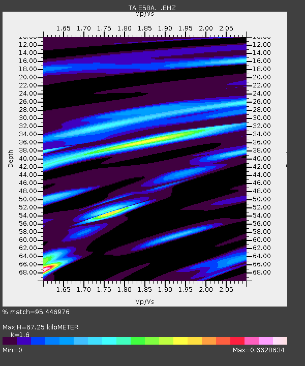
E58A La Victoria, QC, CAN - Earthquake Result Viewer
| Earthquake location: |
Vancouver Island, Canada Region |
| Earthquake latitude/longitude: |
49.8/-127.4 |
| Earthquake time(UTC): |
2014/04/24 (114) 03:10:13 GMT |
| Earthquake Depth: |
11 km |
| Earthquake Magnitude: |
6.7 MWP, 6.7 MI |
| Earthquake Catalog/Contributor: |
NEIC PDE/NEIC COMCAT |
|
| Network: |
TA USArray Transportable Network (new EarthScope stations) |
| Station: |
E58A La Victoria, QC, CAN |
| Lat/Lon: |
46.37 N/73.28 W |
| Elevation: |
233 m |
|
| Distance: |
35.7 deg |
| Az: |
74.278 deg |
| Baz: |
295.846 deg |
| Ray Param: |
0.07709869 |
| Estimated Moho Depth: |
67.25 km |
| Estimated Crust Vp/Vs: |
1.60 |
| Assumed Crust Vp: |
6.61 km/s |
| Estimated Crust Vs: |
4.131 km/s |
| Estimated Crust Poisson's Ratio: |
0.18 |
|
| Radial Match: |
95.446976 % |
| Radial Bump: |
246 |
| Transverse Match: |
69.23812 % |
| Transverse Bump: |
400 |
| SOD ConfigId: |
626651 |
| Insert Time: |
2014-05-08 04:05:58.406 +0000 |
| GWidth: |
2.5 |
| Max Bumps: |
400 |
| Tol: |
0.001 |
|

Signal To Noise
| Channel | StoN | STA | LTA |
| TA:E58A: :BHZ:20140424T03:16:40.175009Z | 11.834373 | 3.951978E-6 | 3.3394062E-7 |
| TA:E58A: :BHN:20140424T03:16:40.175009Z | 4.748573 | 9.190508E-7 | 1.9354253E-7 |
| TA:E58A: :BHE:20140424T03:16:40.175009Z | 12.206341 | 2.4470928E-6 | 2.0047717E-7 |
| Arrivals |
| Ps | 6.7 SECOND |
| PpPs | 24 SECOND |
| PsPs/PpSs | 31 SECOND |


