You are here: Home > Network List > TA - USArray Transportable Network (new EarthScope stations) Stations List
> Station E60A Ste Agathe de Lotbiniere, QC, CAN > Earthquake Result Viewer
E60A Ste Agathe de Lotbiniere, QC, CAN - Earthquake Result Viewer
| Earthquake location: |
Vancouver Island, Canada Region |
| Earthquake latitude/longitude: |
49.8/-127.4 |
| Earthquake time(UTC): |
2014/04/24 (114) 03:10:13 GMT |
| Earthquake Depth: |
11 km |
| Earthquake Magnitude: |
6.7 MWP, 6.7 MI |
| Earthquake Catalog/Contributor: |
NEIC PDE/NEIC COMCAT |
|
| Network: |
TA USArray Transportable Network (new EarthScope stations) |
| Station: |
E60A Ste Agathe de Lotbiniere, QC, CAN |
| Lat/Lon: |
46.37 N/71.45 W |
| Elevation: |
181 m |
|
| Distance: |
36.8 deg |
| Az: |
73.339 deg |
| Baz: |
296.409 deg |
| Ray Param: |
0.07647873 |
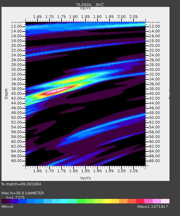
| Estimated Moho Depth: |
38.5 km |
| Estimated Crust Vp/Vs: |
1.73 |
| Assumed Crust Vp: |
6.61 km/s |
| Estimated Crust Vs: |
3.826 km/s |
| Estimated Crust Poisson's Ratio: |
0.25 |
|
| Radial Match: |
89.081894 % |
| Radial Bump: |
400 |
| Transverse Match: |
71.175575 % |
| Transverse Bump: |
400 |
| SOD ConfigId: |
626651 |
| Insert Time: |
2014-05-08 04:06:07.101 +0000 |
| GWidth: |
2.5 |
| Max Bumps: |
400 |
| Tol: |
0.001 |
|
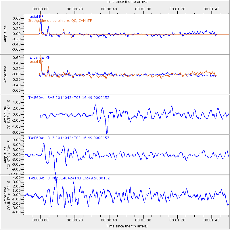
Signal To Noise
| Channel | StoN | STA | LTA |
| TA:E60A: :BHZ:20140424T03:16:49.900015Z | 10.0414715 | 3.841654E-6 | 3.8257878E-7 |
| TA:E60A: :BHN:20140424T03:16:49.900015Z | 3.0456274 | 1.0707212E-6 | 3.5156012E-7 |
| TA:E60A: :BHE:20140424T03:16:49.900015Z | 3.825406 | 1.705388E-6 | 4.4580574E-7 |
| Arrivals |
| Ps | 4.6 SECOND |
| PpPs | 15 SECOND |
| PsPs/PpSs | 19 SECOND |


