You are here: Home > Network List > II - Global Seismograph Network (GSN - IRIS/IDA) Stations List
> Station PFO Pinon Flat, California, USA > Earthquake Result Viewer
PFO Pinon Flat, California, USA - Earthquake Result Viewer
| Earthquake location: |
Southeast Of Loyalty Islands |
| Earthquake latitude/longitude: |
-22.0/170.1 |
| Earthquake time(UTC): |
2001/02/28 (059) 13:05:31 GMT |
| Earthquake Depth: |
10 km |
| Earthquake Magnitude: |
5.8 MB, 6.1 MS, 6.2 MW |
| Earthquake Catalog/Contributor: |
WHDF/NEIC |
|
| Network: |
II Global Seismograph Network (GSN - IRIS/IDA) |
| Station: |
PFO Pinon Flat, California, USA |
| Lat/Lon: |
33.61 N/116.46 W |
| Elevation: |
1280 m |
|
| Distance: |
89.1 deg |
| Az: |
53.131 deg |
| Baz: |
242.828 deg |
| Ray Param: |
0.042090748 |
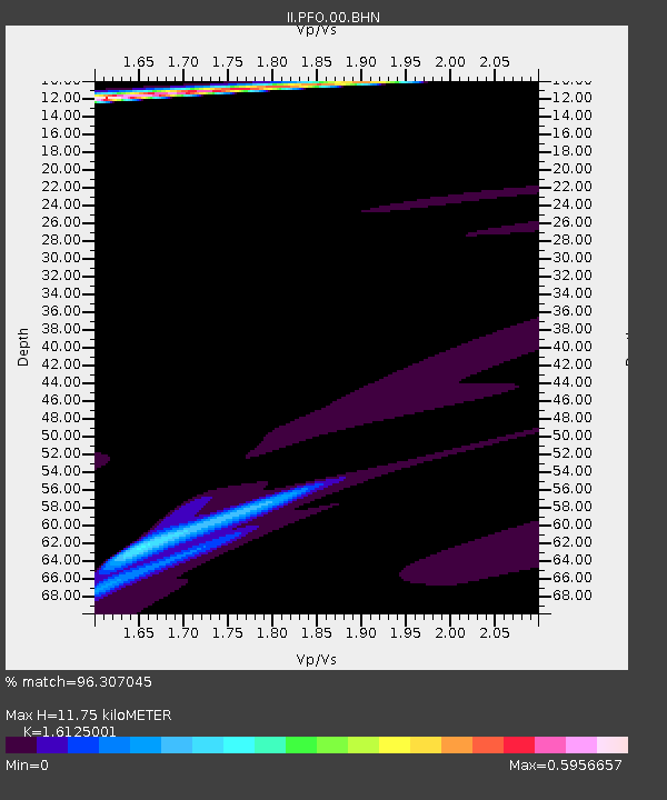
| Estimated Moho Depth: |
11.75 km |
| Estimated Crust Vp/Vs: |
1.61 |
| Assumed Crust Vp: |
6.264 km/s |
| Estimated Crust Vs: |
3.884 km/s |
| Estimated Crust Poisson's Ratio: |
0.19 |
|
| Radial Match: |
96.307045 % |
| Radial Bump: |
275 |
| Transverse Match: |
92.16573 % |
| Transverse Bump: |
362 |
| SOD ConfigId: |
3744 |
| Insert Time: |
2010-03-01 21:29:18.644 +0000 |
| GWidth: |
2.5 |
| Max Bumps: |
400 |
| Tol: |
0.001 |
|

Signal To Noise
| Channel | StoN | STA | LTA |
| II:PFO:00:BHN:20010228T13:17:55.53801Z | 0.8983548 | 8.4933123E-7 | 9.454296E-7 |
| II:PFO:00:BHE:20010228T13:17:55.53801Z | 1.4708523 | 3.62324E-6 | 2.463361E-6 |
| II:PFO:00:BHZ:20010228T13:17:55.53801Z | 1.1009753 | 3.9608094E-6 | 3.5975463E-6 |
| Arrivals |
| Ps | 1.2 SECOND |
| PpPs | 4.8 SECOND |
| PsPs/PpSs | 6.0 SECOND |


