You are here: Home > Network List > TA - USArray Transportable Network (new EarthScope stations) Stations List
> Station H66A Whiting, ME, USA > Earthquake Result Viewer
H66A Whiting, ME, USA - Earthquake Result Viewer
| Earthquake location: |
Vancouver Island, Canada Region |
| Earthquake latitude/longitude: |
49.8/-127.4 |
| Earthquake time(UTC): |
2014/04/24 (114) 03:10:13 GMT |
| Earthquake Depth: |
11 km |
| Earthquake Magnitude: |
6.7 MWP, 6.7 MI |
| Earthquake Catalog/Contributor: |
NEIC PDE/NEIC COMCAT |
|
| Network: |
TA USArray Transportable Network (new EarthScope stations) |
| Station: |
H66A Whiting, ME, USA |
| Lat/Lon: |
44.79 N/67.31 W |
| Elevation: |
55 m |
|
| Distance: |
40.1 deg |
| Az: |
73.402 deg |
| Baz: |
299.403 deg |
| Ray Param: |
0.074578576 |
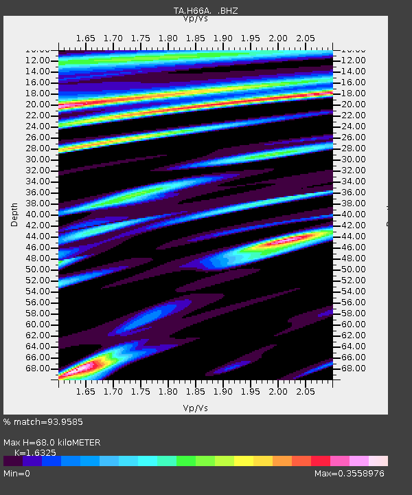
| Estimated Moho Depth: |
68.0 km |
| Estimated Crust Vp/Vs: |
1.63 |
| Assumed Crust Vp: |
6.419 km/s |
| Estimated Crust Vs: |
3.932 km/s |
| Estimated Crust Poisson's Ratio: |
0.20 |
|
| Radial Match: |
93.9585 % |
| Radial Bump: |
266 |
| Transverse Match: |
70.49449 % |
| Transverse Bump: |
400 |
| SOD ConfigId: |
626651 |
| Insert Time: |
2014-05-08 04:08:45.320 +0000 |
| GWidth: |
2.5 |
| Max Bumps: |
400 |
| Tol: |
0.001 |
|

Signal To Noise
| Channel | StoN | STA | LTA |
| TA:H66A: :BHZ:20140424T03:17:17.674001Z | 8.799522 | 3.0352176E-6 | 3.4492982E-7 |
| TA:H66A: :BHN:20140424T03:17:17.674001Z | 2.685797 | 7.2705404E-7 | 2.7070325E-7 |
| TA:H66A: :BHE:20140424T03:17:17.674001Z | 6.067685 | 1.7359147E-6 | 2.8609176E-7 |
| Arrivals |
| Ps | 7.2 SECOND |
| PpPs | 26 SECOND |
| PsPs/PpSs | 33 SECOND |


