You are here: Home > Network List > TA - USArray Transportable Network (new EarthScope stations) Stations List
> Station S56A Natural Bridge, VA, USA > Earthquake Result Viewer
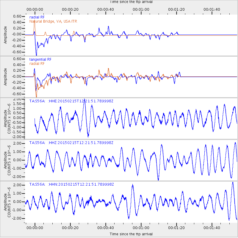
S56A Natural Bridge, VA, USA - Earthquake Result Viewer
*The percent match for this event was below the threshold and hence no stack was calculated.
| Earthquake location: |
North Of Ascension Island |
| Earthquake latitude/longitude: |
-4.5/-12.2 |
| Earthquake time(UTC): |
2015/02/15 (046) 12:10:40 GMT |
| Earthquake Depth: |
10 km |
| Earthquake Magnitude: |
4.9 MW |
| Earthquake Catalog/Contributor: |
ISC/ISC |
|
| Network: |
TA USArray Transportable Network (new EarthScope stations) |
| Station: |
S56A Natural Bridge, VA, USA |
| Lat/Lon: |
37.68 N/79.57 W |
| Elevation: |
449 m |
|
| Distance: |
75.1 deg |
| Az: |
310.717 deg |
| Baz: |
107.755 deg |
| Ray Param: |
$rayparam |
*The percent match for this event was below the threshold and hence was not used in the summary stack. |
|
| Radial Match: |
67.03155 % |
| Radial Bump: |
400 |
| Transverse Match: |
63.532814 % |
| Transverse Bump: |
400 |
| SOD ConfigId: |
7019011 |
| Insert Time: |
2019-04-16 20:23:43.177 +0000 |
| GWidth: |
2.5 |
| Max Bumps: |
400 |
| Tol: |
0.001 |
|
Signal To Noise
| Channel | StoN | STA | LTA |
| TA:S56A: :HHZ:20150215T12:21:51.789998Z | 0.55638564 | 4.8550163E-7 | 8.725991E-7 |
| TA:S56A: :HHN:20150215T12:21:51.789998Z | 0.62368745 | 4.5808696E-7 | 7.3448155E-7 |
| TA:S56A: :HHE:20150215T12:21:51.789998Z | 1.465787 | 9.969531E-7 | 6.801486E-7 |
| Arrivals |
| Ps | |
| PpPs | |
| PsPs/PpSs | |


