You are here: Home > Network List > TA - USArray Transportable Network (new EarthScope stations) Stations List
> Station I52A Shelburne, ON, CAN > Earthquake Result Viewer
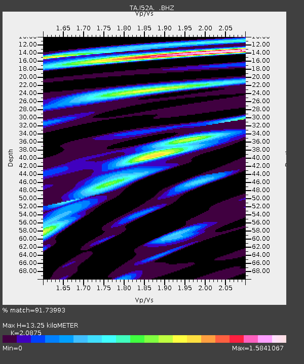
I52A Shelburne, ON, CAN - Earthquake Result Viewer
| Earthquake location: |
Vancouver Island, Canada Region |
| Earthquake latitude/longitude: |
49.8/-127.4 |
| Earthquake time(UTC): |
2014/04/24 (114) 03:10:13 GMT |
| Earthquake Depth: |
11 km |
| Earthquake Magnitude: |
6.7 MWP, 6.7 MI |
| Earthquake Catalog/Contributor: |
NEIC PDE/NEIC COMCAT |
|
| Network: |
TA USArray Transportable Network (new EarthScope stations) |
| Station: |
I52A Shelburne, ON, CAN |
| Lat/Lon: |
44.07 N/80.18 W |
| Elevation: |
505 m |
|
| Distance: |
32.3 deg |
| Az: |
81.859 deg |
| Baz: |
297.252 deg |
| Ray Param: |
0.078697614 |
| Estimated Moho Depth: |
13.25 km |
| Estimated Crust Vp/Vs: |
2.09 |
| Assumed Crust Vp: |
6.53 km/s |
| Estimated Crust Vs: |
3.128 km/s |
| Estimated Crust Poisson's Ratio: |
0.35 |
|
| Radial Match: |
91.73993 % |
| Radial Bump: |
395 |
| Transverse Match: |
70.1097 % |
| Transverse Bump: |
400 |
| SOD ConfigId: |
626651 |
| Insert Time: |
2014-05-08 04:08:55.552 +0000 |
| GWidth: |
2.5 |
| Max Bumps: |
400 |
| Tol: |
0.001 |
|

Signal To Noise
| Channel | StoN | STA | LTA |
| TA:I52A: :BHZ:20140424T03:16:11.274008Z | 5.6237946 | 4.090596E-6 | 7.2737294E-7 |
| TA:I52A: :BHN:20140424T03:16:11.274008Z | 1.6701462 | 1.6375855E-6 | 9.805043E-7 |
| TA:I52A: :BHE:20140424T03:16:11.274008Z | 2.4467132 | 2.5491015E-6 | 1.0418473E-6 |
| Arrivals |
| Ps | 2.4 SECOND |
| PpPs | 5.8 SECOND |
| PsPs/PpSs | 8.2 SECOND |


