You are here: Home > Network List > TA - USArray Transportable Network (new EarthScope stations) Stations List
> Station I60A Shoreham, VT, USA > Earthquake Result Viewer
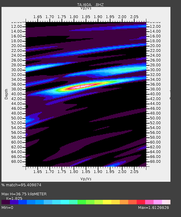
I60A Shoreham, VT, USA - Earthquake Result Viewer
| Earthquake location: |
Vancouver Island, Canada Region |
| Earthquake latitude/longitude: |
49.8/-127.4 |
| Earthquake time(UTC): |
2014/04/24 (114) 03:10:13 GMT |
| Earthquake Depth: |
11 km |
| Earthquake Magnitude: |
6.7 MWP, 6.7 MI |
| Earthquake Catalog/Contributor: |
NEIC PDE/NEIC COMCAT |
|
| Network: |
TA USArray Transportable Network (new EarthScope stations) |
| Station: |
I60A Shoreham, VT, USA |
| Lat/Lon: |
43.84 N/73.29 W |
| Elevation: |
101 m |
|
| Distance: |
36.8 deg |
| Az: |
78.084 deg |
| Baz: |
298.906 deg |
| Ray Param: |
0.07647069 |
| Estimated Moho Depth: |
36.75 km |
| Estimated Crust Vp/Vs: |
1.83 |
| Assumed Crust Vp: |
6.419 km/s |
| Estimated Crust Vs: |
3.517 km/s |
| Estimated Crust Poisson's Ratio: |
0.29 |
|
| Radial Match: |
95.409874 % |
| Radial Bump: |
262 |
| Transverse Match: |
78.67556 % |
| Transverse Bump: |
400 |
| SOD ConfigId: |
626651 |
| Insert Time: |
2014-05-08 04:09:21.286 +0000 |
| GWidth: |
2.5 |
| Max Bumps: |
400 |
| Tol: |
0.001 |
|

Signal To Noise
| Channel | StoN | STA | LTA |
| TA:I60A: :BHZ:20140424T03:16:50.024008Z | 12.485398 | 4.538991E-6 | 3.6354396E-7 |
| TA:I60A: :BHN:20140424T03:16:50.024008Z | 7.0165253 | 1.5862126E-6 | 2.2606811E-7 |
| TA:I60A: :BHE:20140424T03:16:50.024008Z | 9.977109 | 2.939423E-6 | 2.946167E-7 |
| Arrivals |
| Ps | 5.1 SECOND |
| PpPs | 15 SECOND |
| PsPs/PpSs | 20 SECOND |


