You are here: Home > Network List > TA - USArray Transportable Network (new EarthScope stations) Stations List
> Station I63A Otisfield, ME, USA > Earthquake Result Viewer
I63A Otisfield, ME, USA - Earthquake Result Viewer
| Earthquake location: |
Vancouver Island, Canada Region |
| Earthquake latitude/longitude: |
49.8/-127.4 |
| Earthquake time(UTC): |
2014/04/24 (114) 03:10:13 GMT |
| Earthquake Depth: |
11 km |
| Earthquake Magnitude: |
6.7 MWP, 6.7 MI |
| Earthquake Catalog/Contributor: |
NEIC PDE/NEIC COMCAT |
|
| Network: |
TA USArray Transportable Network (new EarthScope stations) |
| Station: |
I63A Otisfield, ME, USA |
| Lat/Lon: |
44.05 N/70.58 W |
| Elevation: |
177 m |
|
| Distance: |
38.4 deg |
| Az: |
76.228 deg |
| Baz: |
299.311 deg |
| Ray Param: |
0.07556438 |
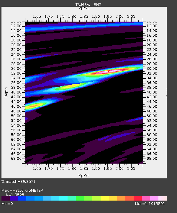
| Estimated Moho Depth: |
31.0 km |
| Estimated Crust Vp/Vs: |
1.95 |
| Assumed Crust Vp: |
6.419 km/s |
| Estimated Crust Vs: |
3.288 km/s |
| Estimated Crust Poisson's Ratio: |
0.32 |
|
| Radial Match: |
89.8571 % |
| Radial Bump: |
332 |
| Transverse Match: |
62.388546 % |
| Transverse Bump: |
400 |
| SOD ConfigId: |
626651 |
| Insert Time: |
2014-05-08 04:09:35.305 +0000 |
| GWidth: |
2.5 |
| Max Bumps: |
400 |
| Tol: |
0.001 |
|

Signal To Noise
| Channel | StoN | STA | LTA |
| TA:I63A: :BHZ:20140424T03:17:03.62499Z | 7.623992 | 3.6063639E-6 | 4.7302828E-7 |
| TA:I63A: :BHN:20140424T03:17:03.62499Z | 2.4834874 | 1.1326314E-6 | 4.560649E-7 |
| TA:I63A: :BHE:20140424T03:17:03.62499Z | 5.8632097 | 1.6024215E-6 | 2.7330108E-7 |
| Arrivals |
| Ps | 4.9 SECOND |
| PpPs | 13 SECOND |
| PsPs/PpSs | 18 SECOND |


