You are here: Home > Network List > TA - USArray Transportable Network (new EarthScope stations) Stations List
> Station K50A Casco, MI, USA > Earthquake Result Viewer
K50A Casco, MI, USA - Earthquake Result Viewer
| Earthquake location: |
Vancouver Island, Canada Region |
| Earthquake latitude/longitude: |
49.8/-127.4 |
| Earthquake time(UTC): |
2014/04/24 (114) 03:10:13 GMT |
| Earthquake Depth: |
11 km |
| Earthquake Magnitude: |
6.7 MWP, 6.7 MI |
| Earthquake Catalog/Contributor: |
NEIC PDE/NEIC COMCAT |
|
| Network: |
TA USArray Transportable Network (new EarthScope stations) |
| Station: |
K50A Casco, MI, USA |
| Lat/Lon: |
42.77 N/82.62 W |
| Elevation: |
191 m |
|
| Distance: |
31.4 deg |
| Az: |
85.609 deg |
| Baz: |
298.762 deg |
| Ray Param: |
0.079089046 |
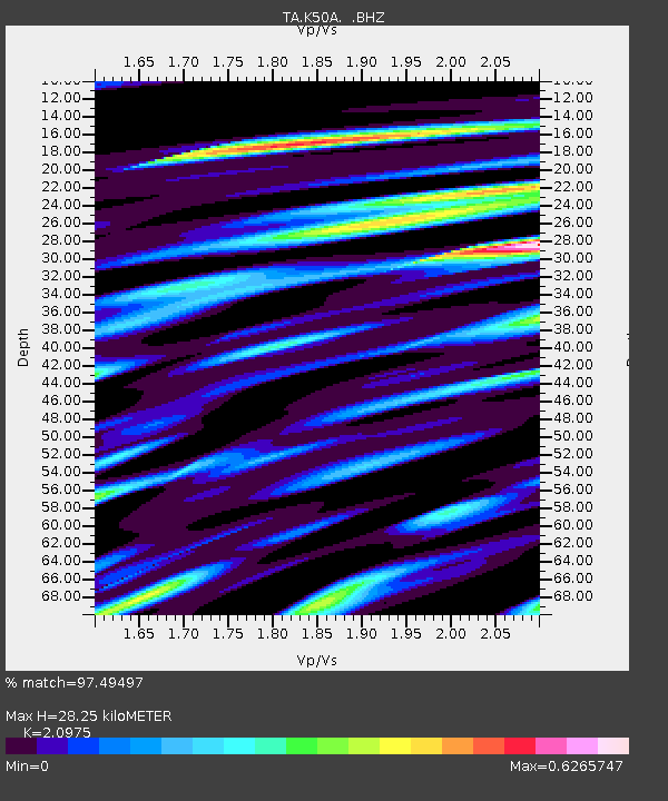
| Estimated Moho Depth: |
28.25 km |
| Estimated Crust Vp/Vs: |
2.10 |
| Assumed Crust Vp: |
6.483 km/s |
| Estimated Crust Vs: |
3.091 km/s |
| Estimated Crust Poisson's Ratio: |
0.35 |
|
| Radial Match: |
97.49497 % |
| Radial Bump: |
311 |
| Transverse Match: |
85.088326 % |
| Transverse Bump: |
400 |
| SOD ConfigId: |
626651 |
| Insert Time: |
2014-05-08 04:10:41.827 +0000 |
| GWidth: |
2.5 |
| Max Bumps: |
400 |
| Tol: |
0.001 |
|
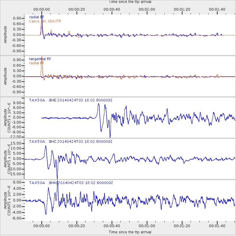
Signal To Noise
| Channel | StoN | STA | LTA |
| TA:K50A: :BHZ:20140424T03:16:02.800009Z | 42.457016 | 6.277053E-6 | 1.478449E-7 |
| TA:K50A: :BHN:20140424T03:16:02.800009Z | 13.269484 | 2.2422316E-6 | 1.6897656E-7 |
| TA:K50A: :BHE:20140424T03:16:02.800009Z | 28.418875 | 4.730545E-6 | 1.6645784E-7 |
| Arrivals |
| Ps | 5.1 SECOND |
| PpPs | 13 SECOND |
| PsPs/PpSs | 18 SECOND |


