You are here: Home > Network List > TA - USArray Transportable Network (new EarthScope stations) Stations List
> Station L48A N Adams, MI, USA > Earthquake Result Viewer
L48A N Adams, MI, USA - Earthquake Result Viewer
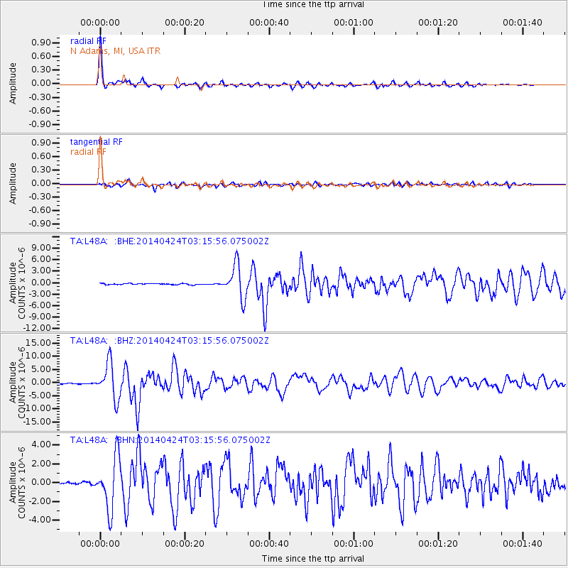
| Earthquake location: |
Vancouver Island, Canada Region |
| Earthquake latitude/longitude: |
49.8/-127.4 |
| Earthquake time(UTC): |
2014/04/24 (114) 03:10:13 GMT |
| Earthquake Depth: |
11 km |
| Earthquake Magnitude: |
6.7 MWP, 6.7 MI |
| Earthquake Catalog/Contributor: |
NEIC PDE/NEIC COMCAT |
|
| Network: |
TA USArray Transportable Network (new EarthScope stations) |
| Station: |
L48A N Adams, MI, USA |
| Lat/Lon: |
41.94 N/84.43 W |
| Elevation: |
369 m |
|
| Distance: |
30.6 deg |
| Az: |
88.292 deg |
| Baz: |
299.848 deg |
| Ray Param: |
0.0792896 |
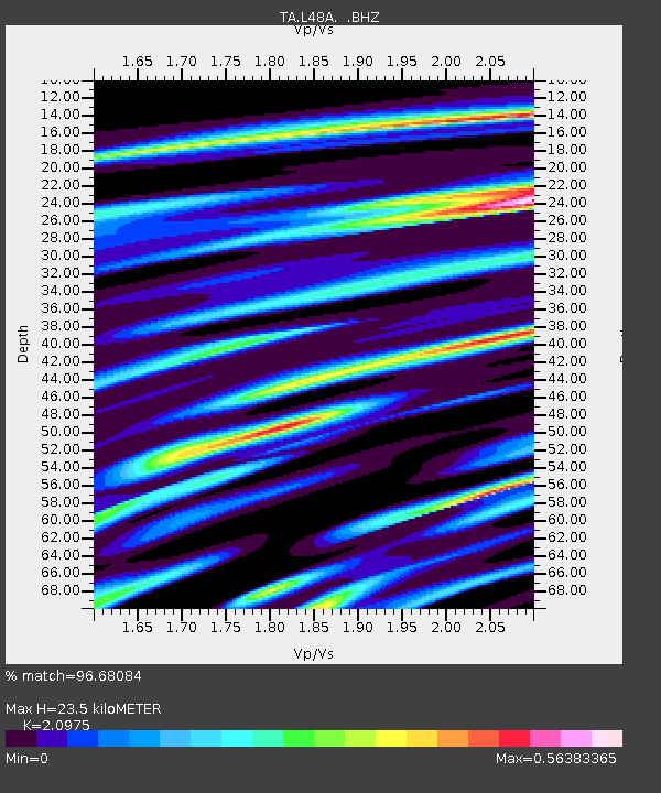
| Estimated Moho Depth: |
23.5 km |
| Estimated Crust Vp/Vs: |
2.10 |
| Assumed Crust Vp: |
6.498 km/s |
| Estimated Crust Vs: |
3.098 km/s |
| Estimated Crust Poisson's Ratio: |
0.35 |
|
| Radial Match: |
96.68084 % |
| Radial Bump: |
303 |
| Transverse Match: |
81.45175 % |
| Transverse Bump: |
400 |
| SOD ConfigId: |
626651 |
| Insert Time: |
2014-05-08 04:11:39.281 +0000 |
| GWidth: |
2.5 |
| Max Bumps: |
400 |
| Tol: |
0.001 |
|
Signal To Noise
| Channel | StoN | STA | LTA |
| TA:L48A: :BHZ:20140424T03:15:56.075002Z | 45.963856 | 7.0312476E-6 | 1.5297341E-7 |
| TA:L48A: :BHN:20140424T03:15:56.075002Z | 13.5733 | 2.8460563E-6 | 2.096805E-7 |
| TA:L48A: :BHE:20140424T03:15:56.075002Z | 31.904608 | 4.501074E-6 | 1.4107911E-7 |
| Arrivals |
| Ps | 4.3 SECOND |
| PpPs | 10 SECOND |
| PsPs/PpSs | 15 SECOND |


