You are here: Home > Network List > TA - USArray Transportable Network (new EarthScope stations) Stations List
> Station M53A WI Miller and Sons, Farmdale, OH, USA > Earthquake Result Viewer
M53A WI Miller and Sons, Farmdale, OH, USA - Earthquake Result Viewer

| Earthquake location: |
Vancouver Island, Canada Region |
| Earthquake latitude/longitude: |
49.8/-127.4 |
| Earthquake time(UTC): |
2014/04/24 (114) 03:10:13 GMT |
| Earthquake Depth: |
11 km |
| Earthquake Magnitude: |
6.7 MWP, 6.7 MI |
| Earthquake Catalog/Contributor: |
NEIC PDE/NEIC COMCAT |
|
| Network: |
TA USArray Transportable Network (new EarthScope stations) |
| Station: |
M53A WI Miller and Sons, Farmdale, OH, USA |
| Lat/Lon: |
41.44 N/80.68 W |
| Elevation: |
334 m |
|
| Distance: |
33.3 deg |
| Az: |
86.43 deg |
| Baz: |
300.758 deg |
| Ray Param: |
0.07827853 |
| Estimated Moho Depth: |
18.0 km |
| Estimated Crust Vp/Vs: |
2.01 |
| Assumed Crust Vp: |
6.483 km/s |
| Estimated Crust Vs: |
3.229 km/s |
| Estimated Crust Poisson's Ratio: |
0.33 |
|
| Radial Match: |
96.246216 % |
| Radial Bump: |
367 |
| Transverse Match: |
84.84497 % |
| Transverse Bump: |
400 |
| SOD ConfigId: |
626651 |
| Insert Time: |
2014-05-08 04:13:12.126 +0000 |
| GWidth: |
2.5 |
| Max Bumps: |
400 |
| Tol: |
0.001 |
|
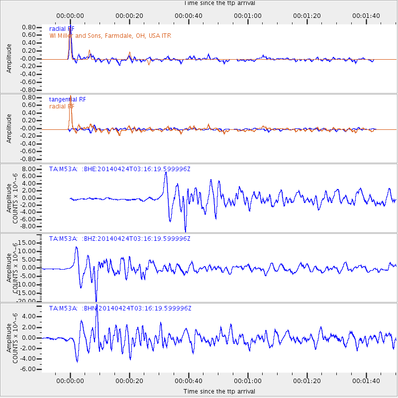
Signal To Noise
| Channel | StoN | STA | LTA |
| TA:M53A: :BHZ:20140424T03:16:19.599996Z | 39.76856 | 6.69927E-6 | 1.6845645E-7 |
| TA:M53A: :BHN:20140424T03:16:19.599996Z | 15.553583 | 2.1002754E-6 | 1.3503482E-7 |
| TA:M53A: :BHE:20140424T03:16:19.599996Z | 20.848269 | 3.7618454E-6 | 1.8043923E-7 |
| Arrivals |
| Ps | 3.0 SECOND |
| PpPs | 7.8 SECOND |
| PsPs/PpSs | 11 SECOND |


