You are here: Home > Network List > TA - USArray Transportable Network (new EarthScope stations) Stations List
> Station N52A McGinn's Farm, Dalton, OH, USA > Earthquake Result Viewer
N52A McGinn's Farm, Dalton, OH, USA - Earthquake Result Viewer
| Earthquake location: |
Vancouver Island, Canada Region |
| Earthquake latitude/longitude: |
49.8/-127.4 |
| Earthquake time(UTC): |
2014/04/24 (114) 03:10:13 GMT |
| Earthquake Depth: |
11 km |
| Earthquake Magnitude: |
6.7 MWP, 6.7 MI |
| Earthquake Catalog/Contributor: |
NEIC PDE/NEIC COMCAT |
|
| Network: |
TA USArray Transportable Network (new EarthScope stations) |
| Station: |
N52A McGinn's Farm, Dalton, OH, USA |
| Lat/Lon: |
40.81 N/81.69 W |
| Elevation: |
331 m |
|
| Distance: |
32.9 deg |
| Az: |
88.134 deg |
| Baz: |
301.523 deg |
| Ray Param: |
0.07843079 |
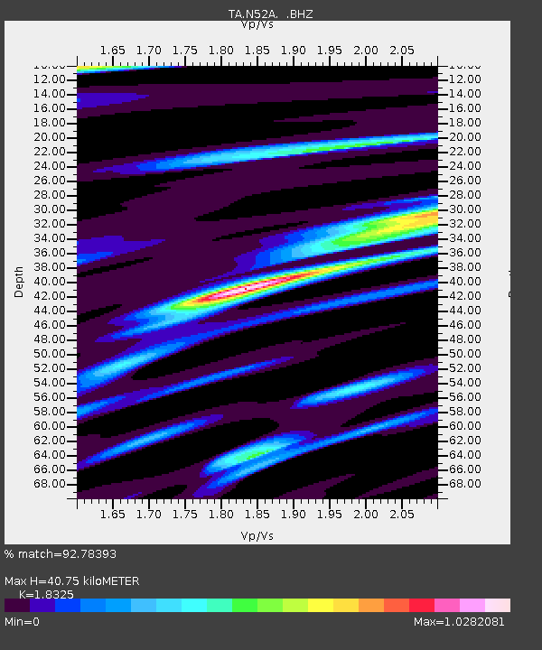
| Estimated Moho Depth: |
40.75 km |
| Estimated Crust Vp/Vs: |
1.83 |
| Assumed Crust Vp: |
6.483 km/s |
| Estimated Crust Vs: |
3.538 km/s |
| Estimated Crust Poisson's Ratio: |
0.29 |
|
| Radial Match: |
92.78393 % |
| Radial Bump: |
338 |
| Transverse Match: |
75.82915 % |
| Transverse Bump: |
400 |
| SOD ConfigId: |
626651 |
| Insert Time: |
2014-05-08 04:14:22.183 +0000 |
| GWidth: |
2.5 |
| Max Bumps: |
400 |
| Tol: |
0.001 |
|

Signal To Noise
| Channel | StoN | STA | LTA |
| TA:N52A: :BHZ:20140424T03:16:16.700002Z | 32.83367 | 5.2182813E-6 | 1.5893079E-7 |
| TA:N52A: :BHN:20140424T03:16:16.700002Z | 11.155263 | 2.1467695E-6 | 1.9244455E-7 |
| TA:N52A: :BHE:20140424T03:16:16.700002Z | 24.148369 | 3.3139486E-6 | 1.372328E-7 |
| Arrivals |
| Ps | 5.7 SECOND |
| PpPs | 16 SECOND |
| PsPs/PpSs | 22 SECOND |


