You are here: Home > Network List > TA - USArray Transportable Network (new EarthScope stations) Stations List
> Station N59A State Game Land 141, Hazleton, PA, USA > Earthquake Result Viewer
N59A State Game Land 141, Hazleton, PA, USA - Earthquake Result Viewer
| Earthquake location: |
Vancouver Island, Canada Region |
| Earthquake latitude/longitude: |
49.8/-127.4 |
| Earthquake time(UTC): |
2014/04/24 (114) 03:10:13 GMT |
| Earthquake Depth: |
11 km |
| Earthquake Magnitude: |
6.7 MWP, 6.7 MI |
| Earthquake Catalog/Contributor: |
NEIC PDE/NEIC COMCAT |
|
| Network: |
TA USArray Transportable Network (new EarthScope stations) |
| Station: |
N59A State Game Land 141, Hazleton, PA, USA |
| Lat/Lon: |
40.92 N/75.77 W |
| Elevation: |
508 m |
|
| Distance: |
36.7 deg |
| Az: |
83.853 deg |
| Baz: |
301.864 deg |
| Ray Param: |
0.07652797 |
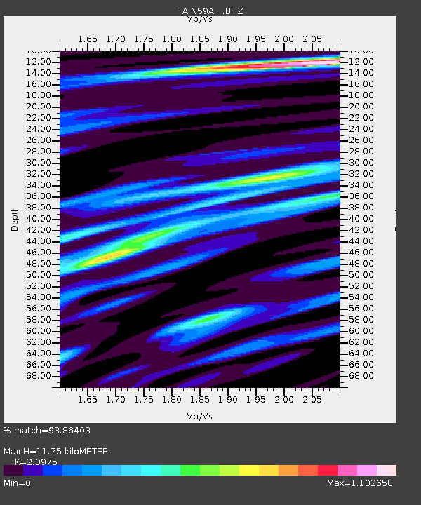
| Estimated Moho Depth: |
11.75 km |
| Estimated Crust Vp/Vs: |
2.10 |
| Assumed Crust Vp: |
6.283 km/s |
| Estimated Crust Vs: |
2.996 km/s |
| Estimated Crust Poisson's Ratio: |
0.35 |
|
| Radial Match: |
93.86403 % |
| Radial Bump: |
400 |
| Transverse Match: |
75.2586 % |
| Transverse Bump: |
400 |
| SOD ConfigId: |
626651 |
| Insert Time: |
2014-05-08 04:14:45.793 +0000 |
| GWidth: |
2.5 |
| Max Bumps: |
400 |
| Tol: |
0.001 |
|
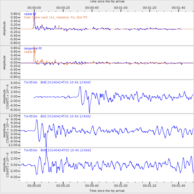
Signal To Noise
| Channel | StoN | STA | LTA |
| TA:N59A: :BHZ:20140424T03:16:49.12499Z | 17.541151 | 5.249702E-6 | 2.9927924E-7 |
| TA:N59A: :BHN:20140424T03:16:49.12499Z | 11.489643 | 1.7899425E-6 | 1.5578748E-7 |
| TA:N59A: :BHE:20140424T03:16:49.12499Z | 13.921817 | 2.5713953E-6 | 1.8470257E-7 |
| Arrivals |
| Ps | 2.2 SECOND |
| PpPs | 5.5 SECOND |
| PsPs/PpSs | 7.6 SECOND |


