You are here: Home > Network List > TA - USArray Transportable Network (new EarthScope stations) Stations List
> Station O48A Farmland, IN, USA > Earthquake Result Viewer
O48A Farmland, IN, USA - Earthquake Result Viewer
| Earthquake location: |
Vancouver Island, Canada Region |
| Earthquake latitude/longitude: |
49.8/-127.4 |
| Earthquake time(UTC): |
2014/04/24 (114) 03:10:13 GMT |
| Earthquake Depth: |
11 km |
| Earthquake Magnitude: |
6.7 MWP, 6.7 MI |
| Earthquake Catalog/Contributor: |
NEIC PDE/NEIC COMCAT |
|
| Network: |
TA USArray Transportable Network (new EarthScope stations) |
| Station: |
O48A Farmland, IN, USA |
| Lat/Lon: |
40.26 N/85.16 W |
| Elevation: |
300 m |
|
| Distance: |
31.0 deg |
| Az: |
91.662 deg |
| Baz: |
302.27 deg |
| Ray Param: |
0.07918403 |
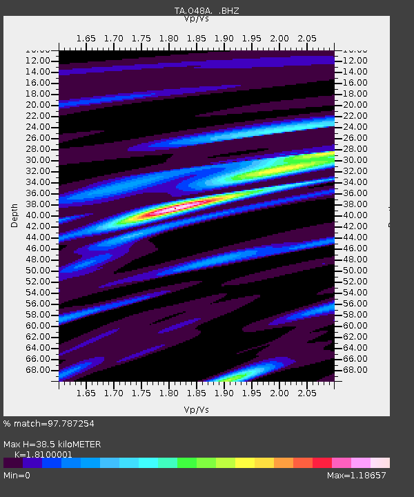
| Estimated Moho Depth: |
38.5 km |
| Estimated Crust Vp/Vs: |
1.81 |
| Assumed Crust Vp: |
6.498 km/s |
| Estimated Crust Vs: |
3.59 km/s |
| Estimated Crust Poisson's Ratio: |
0.28 |
|
| Radial Match: |
97.787254 % |
| Radial Bump: |
275 |
| Transverse Match: |
87.00461 % |
| Transverse Bump: |
400 |
| SOD ConfigId: |
626651 |
| Insert Time: |
2014-05-08 04:15:09.077 +0000 |
| GWidth: |
2.5 |
| Max Bumps: |
400 |
| Tol: |
0.001 |
|
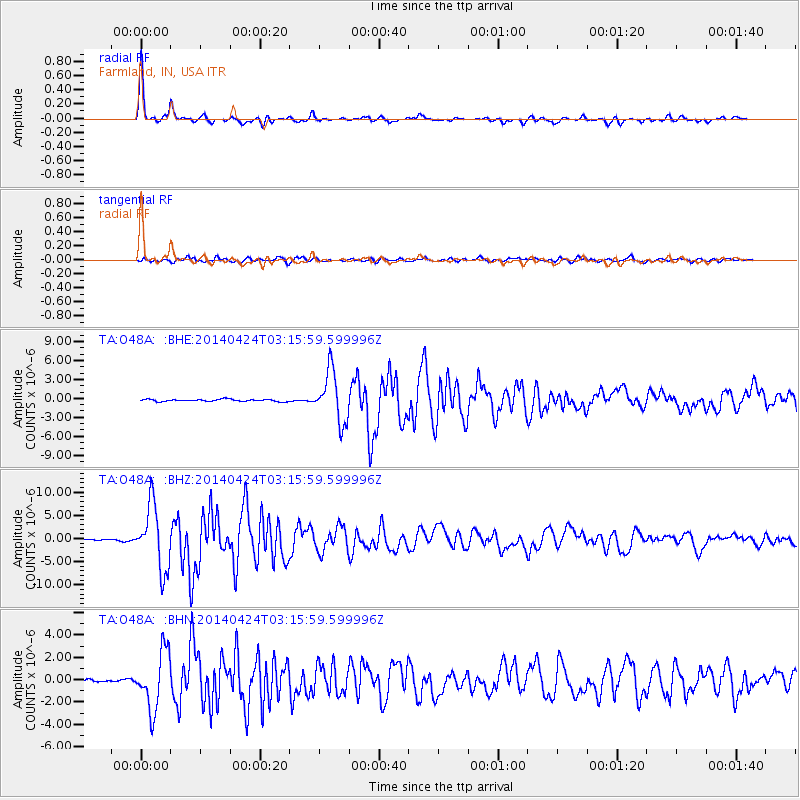
Signal To Noise
| Channel | StoN | STA | LTA |
| TA:O48A: :BHZ:20140424T03:15:59.599996Z | 44.337143 | 6.914653E-6 | 1.5595622E-7 |
| TA:O48A: :BHN:20140424T03:15:59.599996Z | 21.21941 | 2.5911913E-6 | 1.221142E-7 |
| TA:O48A: :BHE:20140424T03:15:59.599996Z | 24.022646 | 3.9932515E-6 | 1.6622863E-7 |
| Arrivals |
| Ps | 5.2 SECOND |
| PpPs | 15 SECOND |
| PsPs/PpSs | 21 SECOND |


