You are here: Home > Network List > TA - USArray Transportable Network (new EarthScope stations) Stations List
> Station P60A Greenville, DE, USA > Earthquake Result Viewer
P60A Greenville, DE, USA - Earthquake Result Viewer
| Earthquake location: |
Vancouver Island, Canada Region |
| Earthquake latitude/longitude: |
49.8/-127.4 |
| Earthquake time(UTC): |
2014/04/24 (114) 03:10:13 GMT |
| Earthquake Depth: |
11 km |
| Earthquake Magnitude: |
6.7 MWP, 6.7 MI |
| Earthquake Catalog/Contributor: |
NEIC PDE/NEIC COMCAT |
|
| Network: |
TA USArray Transportable Network (new EarthScope stations) |
| Station: |
P60A Greenville, DE, USA |
| Lat/Lon: |
39.81 N/75.64 W |
| Elevation: |
105 m |
|
| Distance: |
37.4 deg |
| Az: |
85.307 deg |
| Baz: |
303.111 deg |
| Ray Param: |
0.07615763 |
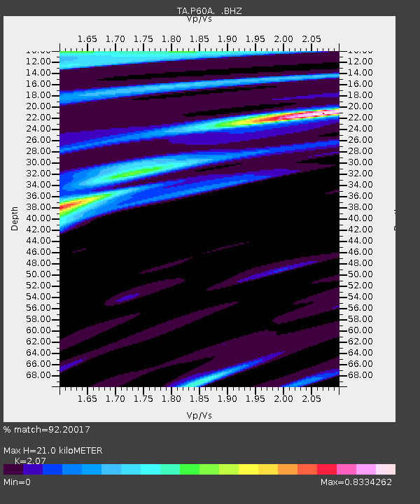
| Estimated Moho Depth: |
21.0 km |
| Estimated Crust Vp/Vs: |
2.07 |
| Assumed Crust Vp: |
6.287 km/s |
| Estimated Crust Vs: |
3.037 km/s |
| Estimated Crust Poisson's Ratio: |
0.35 |
|
| Radial Match: |
92.20017 % |
| Radial Bump: |
400 |
| Transverse Match: |
77.0069 % |
| Transverse Bump: |
400 |
| SOD ConfigId: |
626651 |
| Insert Time: |
2014-05-08 04:16:49.249 +0000 |
| GWidth: |
2.5 |
| Max Bumps: |
400 |
| Tol: |
0.001 |
|

Signal To Noise
| Channel | StoN | STA | LTA |
| TA:P60A: :BHZ:20140424T03:16:54.900015Z | 23.432858 | 3.7400184E-6 | 1.5960573E-7 |
| TA:P60A: :BHN:20140424T03:16:54.900015Z | 6.35833 | 9.724655E-7 | 1.5294354E-7 |
| TA:P60A: :BHE:20140424T03:16:54.900015Z | 9.434129 | 1.482531E-6 | 1.5714551E-7 |
| Arrivals |
| Ps | 3.8 SECOND |
| PpPs | 9.7 SECOND |
| PsPs/PpSs | 13 SECOND |


