You are here: Home > Network List > TA - USArray Transportable Network (new EarthScope stations) Stations List
> Station Q55A Buckhannon, WV, USA > Earthquake Result Viewer
Q55A Buckhannon, WV, USA - Earthquake Result Viewer
| Earthquake location: |
Vancouver Island, Canada Region |
| Earthquake latitude/longitude: |
49.8/-127.4 |
| Earthquake time(UTC): |
2014/04/24 (114) 03:10:13 GMT |
| Earthquake Depth: |
11 km |
| Earthquake Magnitude: |
6.7 MWP, 6.7 MI |
| Earthquake Catalog/Contributor: |
NEIC PDE/NEIC COMCAT |
|
| Network: |
TA USArray Transportable Network (new EarthScope stations) |
| Station: |
Q55A Buckhannon, WV, USA |
| Lat/Lon: |
39.00 N/80.08 W |
| Elevation: |
657 m |
|
| Distance: |
35.0 deg |
| Az: |
89.676 deg |
| Baz: |
303.828 deg |
| Ray Param: |
0.07746506 |
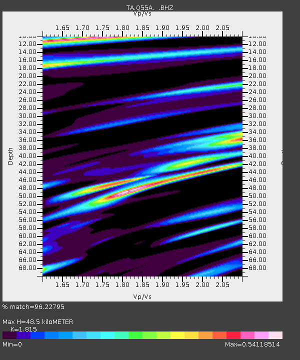
| Estimated Moho Depth: |
48.5 km |
| Estimated Crust Vp/Vs: |
1.82 |
| Assumed Crust Vp: |
6.207 km/s |
| Estimated Crust Vs: |
3.42 km/s |
| Estimated Crust Poisson's Ratio: |
0.28 |
|
| Radial Match: |
96.22795 % |
| Radial Bump: |
355 |
| Transverse Match: |
89.28587 % |
| Transverse Bump: |
400 |
| SOD ConfigId: |
626651 |
| Insert Time: |
2014-05-08 04:17:24.402 +0000 |
| GWidth: |
2.5 |
| Max Bumps: |
400 |
| Tol: |
0.001 |
|

Signal To Noise
| Channel | StoN | STA | LTA |
| TA:Q55A: :BHZ:20140424T03:16:34.200002Z | 25.114721 | 7.51177E-6 | 2.9909828E-7 |
| TA:Q55A: :BHN:20140424T03:16:34.200002Z | 8.783899 | 2.4385502E-6 | 2.776159E-7 |
| TA:Q55A: :BHE:20140424T03:16:34.200002Z | 19.408796 | 3.7432503E-6 | 1.928636E-7 |
| Arrivals |
| Ps | 6.8 SECOND |
| PpPs | 21 SECOND |
| PsPs/PpSs | 27 SECOND |


