You are here: Home > Network List > TA - USArray Transportable Network (new EarthScope stations) Stations List
> Station T58A Grand View Acres, VA, USA > Earthquake Result Viewer
T58A Grand View Acres, VA, USA - Earthquake Result Viewer
| Earthquake location: |
Vancouver Island, Canada Region |
| Earthquake latitude/longitude: |
49.8/-127.4 |
| Earthquake time(UTC): |
2014/04/24 (114) 03:10:13 GMT |
| Earthquake Depth: |
11 km |
| Earthquake Magnitude: |
6.7 MWP, 6.7 MI |
| Earthquake Catalog/Contributor: |
NEIC PDE/NEIC COMCAT |
|
| Network: |
TA USArray Transportable Network (new EarthScope stations) |
| Station: |
T58A Grand View Acres, VA, USA |
| Lat/Lon: |
36.95 N/78.53 W |
| Elevation: |
167 m |
|
| Distance: |
37.1 deg |
| Az: |
91.334 deg |
| Baz: |
306.117 deg |
| Ray Param: |
0.076293774 |
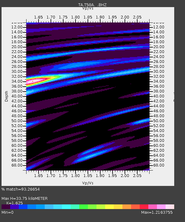
| Estimated Moho Depth: |
33.75 km |
| Estimated Crust Vp/Vs: |
1.62 |
| Assumed Crust Vp: |
6.419 km/s |
| Estimated Crust Vs: |
3.95 km/s |
| Estimated Crust Poisson's Ratio: |
0.20 |
|
| Radial Match: |
93.26654 % |
| Radial Bump: |
400 |
| Transverse Match: |
81.340904 % |
| Transverse Bump: |
400 |
| SOD ConfigId: |
626651 |
| Insert Time: |
2014-05-08 04:19:26.363 +0000 |
| GWidth: |
2.5 |
| Max Bumps: |
400 |
| Tol: |
0.001 |
|
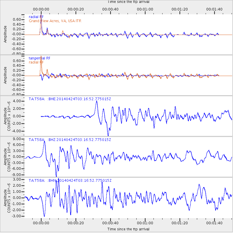
Signal To Noise
| Channel | StoN | STA | LTA |
| TA:T58A: :BHZ:20140424T03:16:52.775015Z | 15.631285 | 3.7417005E-6 | 2.3937255E-7 |
| TA:T58A: :BHN:20140424T03:16:52.775015Z | 11.720869 | 1.2897052E-6 | 1.1003495E-7 |
| TA:T58A: :BHE:20140424T03:16:52.775015Z | 12.598132 | 1.946616E-6 | 1.5451624E-7 |
| Arrivals |
| Ps | 3.6 SECOND |
| PpPs | 13 SECOND |
| PsPs/PpSs | 16 SECOND |


