You are here: Home > Network List > IU - Global Seismograph Network (GSN - IRIS/USGS) Stations List
> Station JOHN Johnston Island, USA > Earthquake Result Viewer
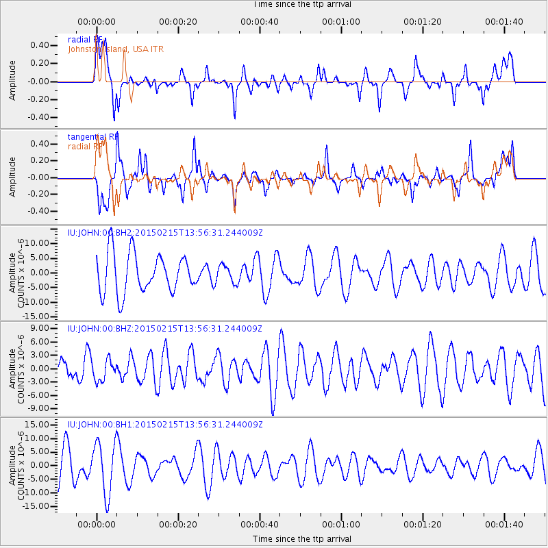
JOHN Johnston Island, USA - Earthquake Result Viewer
*The percent match for this event was below the threshold and hence no stack was calculated.
| Earthquake location: |
Fiji Islands Region |
| Earthquake latitude/longitude: |
-18.4/176.9 |
| Earthquake time(UTC): |
2015/02/15 (046) 13:49:52 GMT |
| Earthquake Depth: |
35 km |
| Earthquake Magnitude: |
5.5 MW |
| Earthquake Catalog/Contributor: |
ISC/ISC |
|
| Network: |
IU Global Seismograph Network (GSN - IRIS/USGS) |
| Station: |
JOHN Johnston Island, USA |
| Lat/Lon: |
16.73 N/169.53 W |
| Elevation: |
2.0 m |
|
| Distance: |
37.4 deg |
| Az: |
21.769 deg |
| Baz: |
201.56 deg |
| Ray Param: |
$rayparam |
*The percent match for this event was below the threshold and hence was not used in the summary stack. |
|
| Radial Match: |
46.82173 % |
| Radial Bump: |
400 |
| Transverse Match: |
61.892334 % |
| Transverse Bump: |
382 |
| SOD ConfigId: |
7019011 |
| Insert Time: |
2019-04-16 20:35:01.757 +0000 |
| GWidth: |
2.5 |
| Max Bumps: |
400 |
| Tol: |
0.001 |
|
Signal To Noise
| Channel | StoN | STA | LTA |
| IU:JOHN:00:BHZ:20150215T13:56:31.244009Z | 1.1398872 | 2.336354E-6 | 2.0496361E-6 |
| IU:JOHN:00:BH1:20150215T13:56:31.244009Z | 1.9262989 | 9.884612E-6 | 5.1314014E-6 |
| IU:JOHN:00:BH2:20150215T13:56:31.244009Z | 0.4533812 | 3.0493695E-6 | 6.72584E-6 |
| Arrivals |
| Ps | |
| PpPs | |
| PsPs/PpSs | |


