You are here: Home > Network List > II - Global Seismograph Network (GSN - IRIS/IDA) Stations List
> Station PFO Pinon Flat, California, USA > Earthquake Result Viewer
PFO Pinon Flat, California, USA - Earthquake Result Viewer

| Earthquake location: |
Hokkaido, Japan Region |
| Earthquake latitude/longitude: |
43.0/145.1 |
| Earthquake time(UTC): |
2004/11/28 (333) 18:32:14 GMT |
| Earthquake Depth: |
39 km |
| Earthquake Magnitude: |
6.4 MB, 6.7 MS, 7.0 MW, 7.0 MW |
| Earthquake Catalog/Contributor: |
WHDF/NEIC |
|
| Network: |
II Global Seismograph Network (GSN - IRIS/IDA) |
| Station: |
PFO Pinon Flat, California, USA |
| Lat/Lon: |
33.61 N/116.46 W |
| Elevation: |
1280 m |
|
| Distance: |
73.5 deg |
| Az: |
59.449 deg |
| Baz: |
310.801 deg |
| Ray Param: |
0.052927285 |
| Estimated Moho Depth: |
30.25 km |
| Estimated Crust Vp/Vs: |
1.71 |
| Assumed Crust Vp: |
6.264 km/s |
| Estimated Crust Vs: |
3.663 km/s |
| Estimated Crust Poisson's Ratio: |
0.24 |
|
| Radial Match: |
95.7505 % |
| Radial Bump: |
332 |
| Transverse Match: |
90.08762 % |
| Transverse Bump: |
395 |
| SOD ConfigId: |
2459 |
| Insert Time: |
2010-03-01 21:30:09.643 +0000 |
| GWidth: |
2.5 |
| Max Bumps: |
400 |
| Tol: |
0.001 |
|
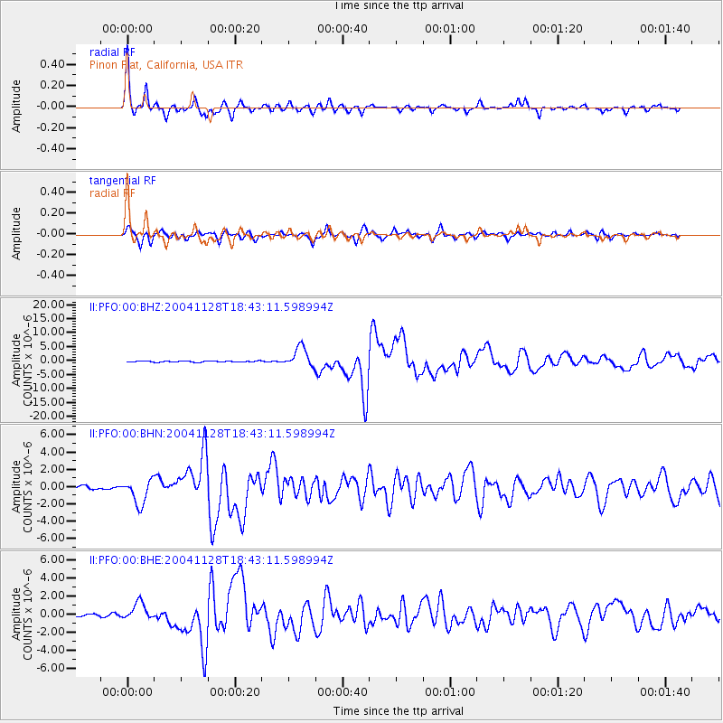
Signal To Noise
| Channel | StoN | STA | LTA |
| II:PFO:00:BHN:20041128T18:43:11.598994Z | 9.094481 | 1.4581764E-6 | 1.6033638E-7 |
| II:PFO:00:BHE:20041128T18:43:11.598994Z | 8.724326 | 9.906994E-7 | 1.13555984E-7 |
| II:PFO:00:BHZ:20041128T18:43:11.598994Z | 17.256577 | 3.5937676E-6 | 2.0825496E-7 |
| Arrivals |
| Ps | 3.5 SECOND |
| PpPs | 13 SECOND |
| PsPs/PpSs | 16 SECOND |


