You are here: Home > Network List > TA - USArray Transportable Network (new EarthScope stations) Stations List
> Station X55A Gracelyn & Ava, Whitmire, SC, USA > Earthquake Result Viewer
X55A Gracelyn & Ava, Whitmire, SC, USA - Earthquake Result Viewer
| Earthquake location: |
Vancouver Island, Canada Region |
| Earthquake latitude/longitude: |
49.8/-127.4 |
| Earthquake time(UTC): |
2014/04/24 (114) 03:10:13 GMT |
| Earthquake Depth: |
11 km |
| Earthquake Magnitude: |
6.7 MWP, 6.7 MI |
| Earthquake Catalog/Contributor: |
NEIC PDE/NEIC COMCAT |
|
| Network: |
TA USArray Transportable Network (new EarthScope stations) |
| Station: |
X55A Gracelyn & Ava, Whitmire, SC, USA |
| Lat/Lon: |
34.47 N/81.63 W |
| Elevation: |
153 m |
|
| Distance: |
36.6 deg |
| Az: |
97.158 deg |
| Baz: |
308.974 deg |
| Ray Param: |
0.076564044 |
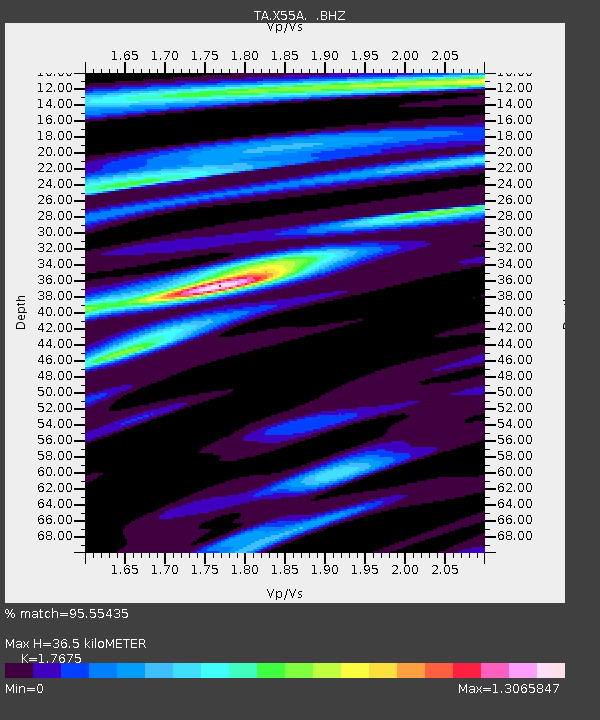
| Estimated Moho Depth: |
36.5 km |
| Estimated Crust Vp/Vs: |
1.77 |
| Assumed Crust Vp: |
6.419 km/s |
| Estimated Crust Vs: |
3.632 km/s |
| Estimated Crust Poisson's Ratio: |
0.26 |
|
| Radial Match: |
95.55435 % |
| Radial Bump: |
250 |
| Transverse Match: |
84.98637 % |
| Transverse Bump: |
400 |
| SOD ConfigId: |
626651 |
| Insert Time: |
2014-05-08 04:21:30.868 +0000 |
| GWidth: |
2.5 |
| Max Bumps: |
400 |
| Tol: |
0.001 |
|
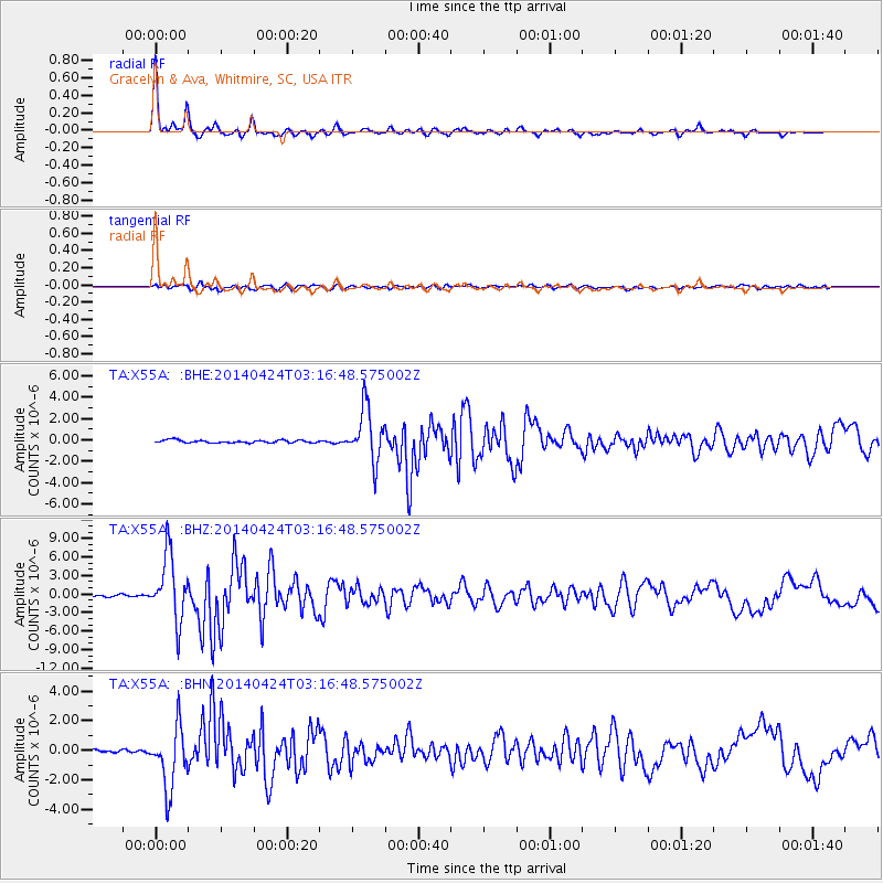
Signal To Noise
| Channel | StoN | STA | LTA |
| TA:X55A: :BHZ:20140424T03:16:48.575002Z | 36.476788 | 5.2768323E-6 | 1.4466275E-7 |
| TA:X55A: :BHN:20140424T03:16:48.575002Z | 18.452726 | 2.0876694E-6 | 1.131361E-7 |
| TA:X55A: :BHE:20140424T03:16:48.575002Z | 19.375608 | 2.458216E-6 | 1.2687168E-7 |
| Arrivals |
| Ps | 4.7 SECOND |
| PpPs | 15 SECOND |
| PsPs/PpSs | 19 SECOND |


