You are here: Home > Network List > TA - USArray Transportable Network (new EarthScope stations) Stations List
> Station X59A McDuffie Farm, Elizabethtown, NC, USA > Earthquake Result Viewer
X59A McDuffie Farm, Elizabethtown, NC, USA - Earthquake Result Viewer
| Earthquake location: |
Vancouver Island, Canada Region |
| Earthquake latitude/longitude: |
49.8/-127.4 |
| Earthquake time(UTC): |
2014/04/24 (114) 03:10:13 GMT |
| Earthquake Depth: |
11 km |
| Earthquake Magnitude: |
6.7 MWP, 6.7 MI |
| Earthquake Catalog/Contributor: |
NEIC PDE/NEIC COMCAT |
|
| Network: |
TA USArray Transportable Network (new EarthScope stations) |
| Station: |
X59A McDuffie Farm, Elizabethtown, NC, USA |
| Lat/Lon: |
34.57 N/78.60 W |
| Elevation: |
29 m |
|
| Distance: |
38.5 deg |
| Az: |
94.459 deg |
| Baz: |
308.545 deg |
| Ray Param: |
0.07550272 |
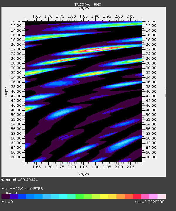
| Estimated Moho Depth: |
22.0 km |
| Estimated Crust Vp/Vs: |
1.90 |
| Assumed Crust Vp: |
6.565 km/s |
| Estimated Crust Vs: |
3.455 km/s |
| Estimated Crust Poisson's Ratio: |
0.31 |
|
| Radial Match: |
89.40644 % |
| Radial Bump: |
400 |
| Transverse Match: |
68.681854 % |
| Transverse Bump: |
400 |
| SOD ConfigId: |
626651 |
| Insert Time: |
2014-05-08 04:21:46.201 +0000 |
| GWidth: |
2.5 |
| Max Bumps: |
400 |
| Tol: |
0.001 |
|

Signal To Noise
| Channel | StoN | STA | LTA |
| TA:X59A: :BHZ:20140424T03:17:04.525015Z | 21.271313 | 4.092442E-6 | 1.9239253E-7 |
| TA:X59A: :BHN:20140424T03:17:04.525015Z | 8.867313 | 1.9956408E-6 | 2.2505587E-7 |
| TA:X59A: :BHE:20140424T03:17:04.525015Z | 10.9418335 | 2.8759519E-6 | 2.6284005E-7 |
| Arrivals |
| Ps | 3.2 SECOND |
| PpPs | 9.1 SECOND |
| PsPs/PpSs | 12 SECOND |


