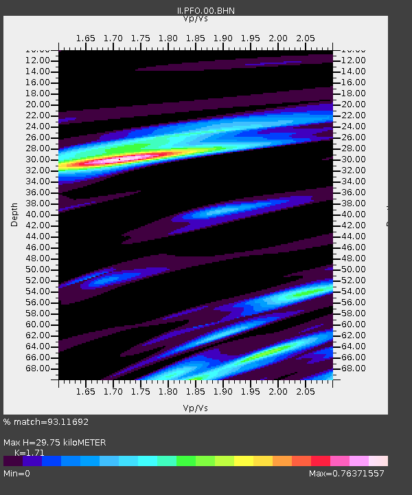
PFO Pinon Flat, California, USA - Earthquake Result Viewer
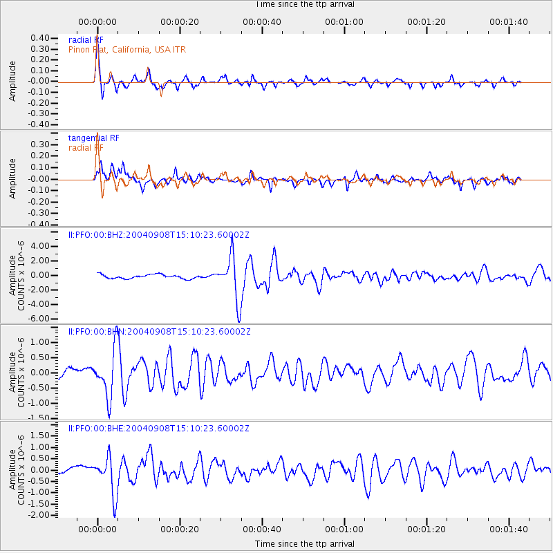
Earthquake location: Near S. Coast Of Honshu, Japan
Earthquake latitude/longitude: 33.1/137.2
Earthquake time(UTC): 2004/09/08 (252) 14:58:25 GMT
Earthquake Depth: 21 km
Earthquake Magnitude: 6.2 MB, 5.8 MS, 6.2 MW, 6.1 MW
Earthquake Catalog/Contributor: WHDF/NEIC
Network: II Global Seismograph Network (GSN - IRIS/IDA)
Station: PFO Pinon Flat, California, USA
Lat/Lon: 33.61 N/116.46 W
Elevation: 1280 m
Distance: 84.1 deg
Az: 53.617 deg
Baz: 305.964 deg
Ray Param: 0.04569767
Estimated Moho Depth: 29.75 km
Estimated Crust Vp/Vs: 1.71
Assumed Crust Vp: 6.264 km/s
Estimated Crust Vs: 3.663 km/s
Estimated Crust Poisson's Ratio: 0.24
Radial Match: 93.11692 %
Radial Bump: 301
Transverse Match: 87.01355 %
Transverse Bump: 400
SOD ConfigId: 2459
Insert Time: 2010-03-01 21:30:19.302 +0000
GWidth: 2.5
Max Bumps: 400
Tol: 0.001

Signal To Noise

ChannelStoNSTALTA
II:PFO:00:BHN:20040908T15:10:23.60002Z5.7389478.0305676E-71.3993103E-7
II:PFO:00:BHE:20040908T15:10:23.60002Z4.10759268.625089E-72.0997918E-7
II:PFO:00:BHZ:20040908T15:10:23.60002Z11.3426183.1449167E-62.772655E-7
Arrivals
Ps3.5 SECOND
PpPs13 SECOND
PsPs/PpSs16 SECOND