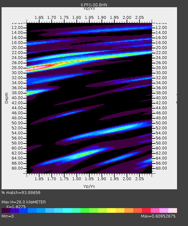
PFO Pinon Flat, California, USA - Earthquake Result Viewer
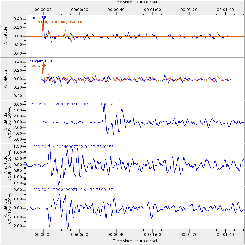
Earthquake location: Santiago Del Estero Prov., Arg.
Earthquake latitude/longitude: -28.6/-65.8
Earthquake time(UTC): 2004/09/07 (251) 11:53:06 GMT
Earthquake Depth: 22 km
Earthquake Magnitude: 6.1 MB, 6.1 MS, 6.4 MW, 6.2 MW
Earthquake Catalog/Contributor: WHDF/NEIC
Network: II Global Seismograph Network (GSN - IRIS/IDA)
Station: PFO Pinon Flat, California, USA
Lat/Lon: 33.61 N/116.46 W
Elevation: 1280 m
Distance: 78.3 deg
Az: 318.79 deg
Baz: 136.024 deg
Ray Param: 0.049744982
Estimated Moho Depth: 28.0 km
Estimated Crust Vp/Vs: 1.63
Assumed Crust Vp: 6.264 km/s
Estimated Crust Vs: 3.849 km/s
Estimated Crust Poisson's Ratio: 0.20
Radial Match: 93.88659 %
Radial Bump: 339
Transverse Match: 86.320496 %
Transverse Bump: 400
SOD ConfigId: 2459
Insert Time: 2010-03-01 21:30:20.489 +0000
GWidth: 2.5
Max Bumps: 400
Tol: 0.001

Signal To Noise

ChannelStoNSTALTA
II:PFO:00:BHN:20040907T12:04:32.750015Z4.87251856.2311483E-71.2788352E-7
II:PFO:00:BHE:20040907T12:04:32.750015Z7.21005447.427474E-71.0301551E-7
II:PFO:00:BHZ:20040907T12:04:32.750015Z10.8126132.5309896E-62.3407753E-7
Arrivals
Ps2.9 SECOND
PpPs11 SECOND
PsPs/PpSs14 SECOND