You are here: Home > Network List > US - United States National Seismic Network Stations List
> Station ERPA Erie, Pennsylvania, USA > Earthquake Result Viewer
ERPA Erie, Pennsylvania, USA - Earthquake Result Viewer
| Earthquake location: |
Vancouver Island, Canada Region |
| Earthquake latitude/longitude: |
49.8/-127.4 |
| Earthquake time(UTC): |
2014/04/24 (114) 03:10:13 GMT |
| Earthquake Depth: |
11 km |
| Earthquake Magnitude: |
6.7 MWP, 6.7 MI |
| Earthquake Catalog/Contributor: |
NEIC PDE/NEIC COMCAT |
|
| Network: |
US United States National Seismic Network |
| Station: |
ERPA Erie, Pennsylvania, USA |
| Lat/Lon: |
42.12 N/79.99 W |
| Elevation: |
306 m |
|
| Distance: |
33.4 deg |
| Az: |
84.894 deg |
| Baz: |
299.93 deg |
| Ray Param: |
0.0782323 |
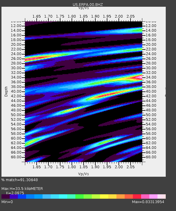
| Estimated Moho Depth: |
33.5 km |
| Estimated Crust Vp/Vs: |
2.10 |
| Assumed Crust Vp: |
6.419 km/s |
| Estimated Crust Vs: |
3.06 km/s |
| Estimated Crust Poisson's Ratio: |
0.35 |
|
| Radial Match: |
91.30648 % |
| Radial Bump: |
301 |
| Transverse Match: |
76.59105 % |
| Transverse Bump: |
400 |
| SOD ConfigId: |
626651 |
| Insert Time: |
2014-05-08 04:24:08.498 +0000 |
| GWidth: |
2.5 |
| Max Bumps: |
400 |
| Tol: |
0.001 |
|

Signal To Noise
| Channel | StoN | STA | LTA |
| US:ERPA:00:BHZ:20140424T03:16:20.450002Z | 24.319176 | 5.0137833E-6 | 2.0616582E-7 |
| US:ERPA:00:BH1:20140424T03:16:20.450002Z | 6.4430194 | 1.5174378E-6 | 2.3551655E-7 |
| US:ERPA:00:BH2:20140424T03:16:20.450002Z | 16.979944 | 2.8651973E-6 | 1.6874009E-7 |
| Arrivals |
| Ps | 6.1 SECOND |
| PpPs | 15 SECOND |
| PsPs/PpSs | 21 SECOND |


