You are here: Home > Network List > OV - Observatorio Vulcanolżgico y Sismolżgico de Costa Rica Stations List
> Station INDI Punta Indio, Guanacaste > Earthquake Result Viewer
INDI Punta Indio, Guanacaste - Earthquake Result Viewer
| Earthquake location: |
South Sandwich Islands Region |
| Earthquake latitude/longitude: |
-55.5/-28.2 |
| Earthquake time(UTC): |
2015/02/16 (047) 22:00:53 GMT |
| Earthquake Depth: |
10 km |
| Earthquake Magnitude: |
6.2 MWW, 6.7 MI |
| Earthquake Catalog/Contributor: |
NEIC PDE/NEIC COMCAT |
|
| Network: |
OV Observatorio Vulcanolżgico y Sismolżgico de Costa Rica |
| Station: |
INDI Punta Indio, Guanacaste |
| Lat/Lon: |
9.87 N/85.50 W |
| Elevation: |
74 m |
|
| Distance: |
80.6 deg |
| Az: |
302.852 deg |
| Baz: |
151.005 deg |
| Ray Param: |
0.04815279 |
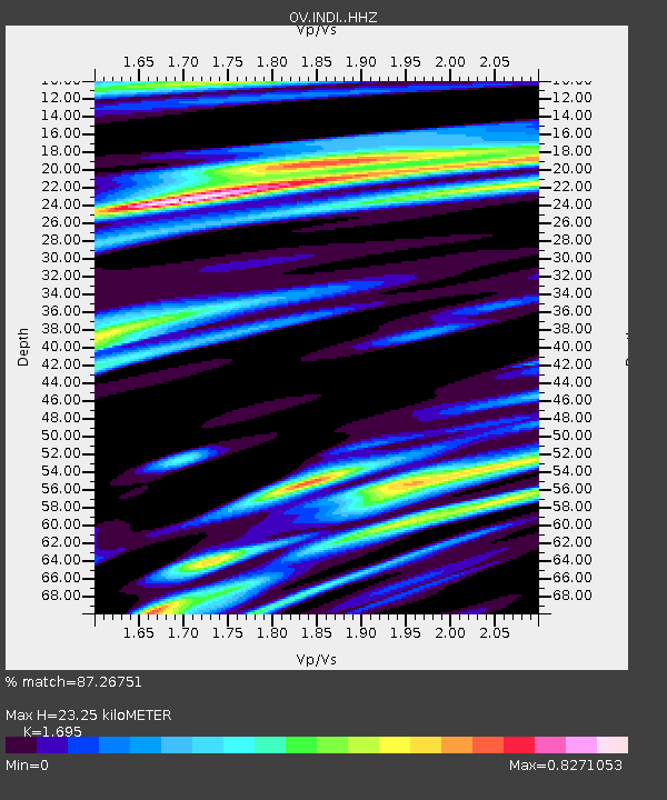
| Estimated Moho Depth: |
23.25 km |
| Estimated Crust Vp/Vs: |
1.70 |
| Assumed Crust Vp: |
6.183 km/s |
| Estimated Crust Vs: |
3.648 km/s |
| Estimated Crust Poisson's Ratio: |
0.23 |
|
| Radial Match: |
87.26751 % |
| Radial Bump: |
400 |
| Transverse Match: |
72.32014 % |
| Transverse Bump: |
400 |
| SOD ConfigId: |
7019011 |
| Insert Time: |
2019-04-16 20:41:02.421 +0000 |
| GWidth: |
2.5 |
| Max Bumps: |
400 |
| Tol: |
0.001 |
|

Signal To Noise
| Channel | StoN | STA | LTA |
| OV:INDI: :HHZ:20150216T22:12:34.404995Z | 6.7522335 | 1.7382149E-6 | 2.5742813E-7 |
| OV:INDI: :HHN:20150216T22:12:34.404995Z | 1.9773922 | 5.7837156E-7 | 2.9249208E-7 |
| OV:INDI: :HHE:20150216T22:12:34.404995Z | 1.2128278 | 2.8309148E-7 | 2.3341441E-7 |
| Arrivals |
| Ps | 2.7 SECOND |
| PpPs | 9.9 SECOND |
| PsPs/PpSs | 13 SECOND |


