You are here: Home > Network List > II - Global Seismograph Network (GSN - IRIS/IDA) Stations List
> Station PFO Pinon Flat, California, USA > Earthquake Result Viewer
PFO Pinon Flat, California, USA - Earthquake Result Viewer
*The percent match for this event was below the threshold and hence no stack was calculated.
| Earthquake location: |
Peru-Bolivia Border Region |
| Earthquake latitude/longitude: |
-15.6/-69.3 |
| Earthquake time(UTC): |
2009/09/30 (273) 19:03:17 GMT |
| Earthquake Depth: |
255 km |
| Earthquake Magnitude: |
5.9 MB, 5.8 MW |
| Earthquake Catalog/Contributor: |
WHDF/NEIC |
|
| Network: |
II Global Seismograph Network (GSN - IRIS/IDA) |
| Station: |
PFO Pinon Flat, California, USA |
| Lat/Lon: |
33.61 N/116.46 W |
| Elevation: |
1280 m |
|
| Distance: |
66.4 deg |
| Az: |
318.109 deg |
| Baz: |
129.538 deg |
| Ray Param: |
$rayparam |
*The percent match for this event was below the threshold and hence was not used in the summary stack. |
|
| Radial Match: |
70.06901 % |
| Radial Bump: |
396 |
| Transverse Match: |
55.667206 % |
| Transverse Bump: |
400 |
| SOD ConfigId: |
1 |
| Insert Time: |
2010-02-19 00:25:37.482 +0000 |
| GWidth: |
2.5 |
| Max Bumps: |
400 |
| Tol: |
0.001 |
|
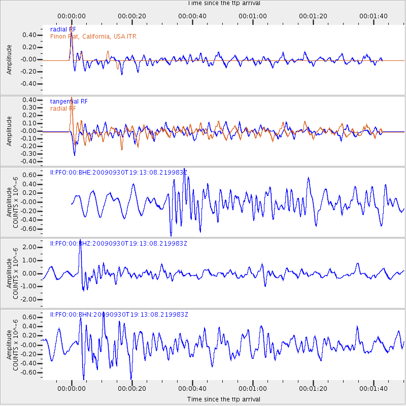
Signal To Noise
| Channel | StoN | STA | LTA |
| II:PFO:00:BHZ:20090930T19:13:08.219983Z | 3.4891737 | 9.177945E-7 | 2.6304068E-7 |
| II:PFO:00:BHN:20090930T19:13:08.219983Z | 2.0202963 | 3.1093356E-7 | 1.5390492E-7 |
| II:PFO:00:BHE:20090930T19:13:08.219983Z | 1.587645 | 3.060462E-7 | 1.9276737E-7 |
| Arrivals |
| Ps | |
| PpPs | |
| PsPs/PpSs | |


