You are here: Home > Network List > IU - Global Seismograph Network (GSN - IRIS/USGS) Stations List
> Station PMG Port Moresby, New Guinea > Earthquake Result Viewer
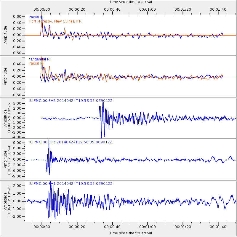
PMG Port Moresby, New Guinea - Earthquake Result Viewer
*The percent match for this event was below the threshold and hence no stack was calculated.
| Earthquake location: |
South Of Fiji Islands |
| Earthquake latitude/longitude: |
-23.9/-176.7 |
| Earthquake time(UTC): |
2014/04/24 (114) 19:51:59 GMT |
| Earthquake Depth: |
66 km |
| Earthquake Magnitude: |
5.9 M |
| Earthquake Catalog/Contributor: |
NEIC PDE/NEIC ALERT |
|
| Network: |
IU Global Seismograph Network (GSN - IRIS/USGS) |
| Station: |
PMG Port Moresby, New Guinea |
| Lat/Lon: |
9.40 S/147.16 E |
| Elevation: |
90 m |
|
| Distance: |
37.3 deg |
| Az: |
286.595 deg |
| Baz: |
117.302 deg |
| Ray Param: |
$rayparam |
*The percent match for this event was below the threshold and hence was not used in the summary stack. |
|
| Radial Match: |
84.64109 % |
| Radial Bump: |
400 |
| Transverse Match: |
78.03221 % |
| Transverse Bump: |
400 |
| SOD ConfigId: |
626651 |
| Insert Time: |
2014-05-08 20:20:48.835 +0000 |
| GWidth: |
2.5 |
| Max Bumps: |
400 |
| Tol: |
0.001 |
|
Signal To Noise
| Channel | StoN | STA | LTA |
| IU:PMG:00:BHZ:20140424T19:58:35.069012Z | 37.17475 | 3.4296088E-6 | 9.22564E-8 |
| IU:PMG:00:BH1:20140424T19:58:35.069012Z | 7.6090374 | 8.075894E-7 | 1.0613555E-7 |
| IU:PMG:00:BH2:20140424T19:58:35.069012Z | 13.376179 | 1.3064172E-6 | 9.766744E-8 |
| Arrivals |
| Ps | |
| PpPs | |
| PsPs/PpSs | |


