You are here: Home > Network List > YT07 - POLENET Stations List
> Station BENN BENN > Earthquake Result Viewer
BENN BENN - Earthquake Result Viewer
| Earthquake location: |
South Sandwich Islands Region |
| Earthquake latitude/longitude: |
-55.5/-28.2 |
| Earthquake time(UTC): |
2015/02/16 (047) 22:00:53 GMT |
| Earthquake Depth: |
10 km |
| Earthquake Magnitude: |
6.2 MWW, 6.7 MI |
| Earthquake Catalog/Contributor: |
NEIC PDE/NEIC COMCAT |
|
| Network: |
YT POLENET |
| Station: |
BENN BENN |
| Lat/Lon: |
84.57 S/117.39 W |
| Elevation: |
1308 m |
|
| Distance: |
34.9 deg |
| Az: |
189.567 deg |
| Baz: |
97.011 deg |
| Ray Param: |
0.07747875 |
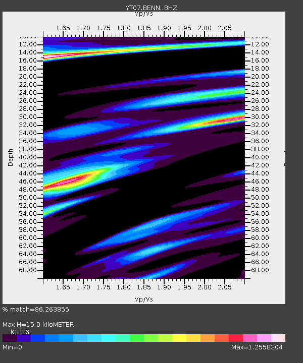
| Estimated Moho Depth: |
15.0 km |
| Estimated Crust Vp/Vs: |
1.60 |
| Assumed Crust Vp: |
6.306 km/s |
| Estimated Crust Vs: |
3.941 km/s |
| Estimated Crust Poisson's Ratio: |
0.18 |
|
| Radial Match: |
86.263855 % |
| Radial Bump: |
400 |
| Transverse Match: |
75.85473 % |
| Transverse Bump: |
400 |
| SOD ConfigId: |
7019011 |
| Insert Time: |
2019-04-16 20:42:08.888 +0000 |
| GWidth: |
2.5 |
| Max Bumps: |
400 |
| Tol: |
0.001 |
|

Signal To Noise
| Channel | StoN | STA | LTA |
| YT:BENN: :BHZ:20150216T22:07:14.499996Z | 13.784116 | 1.7066105E-6 | 1.2380993E-7 |
| YT:BENN: :BHN:20150216T22:07:14.499996Z | 2.9354472 | 7.6711694E-7 | 2.613288E-7 |
| YT:BENN: :BHE:20150216T22:07:14.499996Z | 2.5766466 | 5.938486E-7 | 2.3047345E-7 |
| Arrivals |
| Ps | 1.5 SECOND |
| PpPs | 5.7 SECOND |
| PsPs/PpSs | 7.2 SECOND |


