You are here: Home > Network List > US - United States National Seismic Network Stations List
> Station EGMT Eagleton, Montana, USA > Earthquake Result Viewer
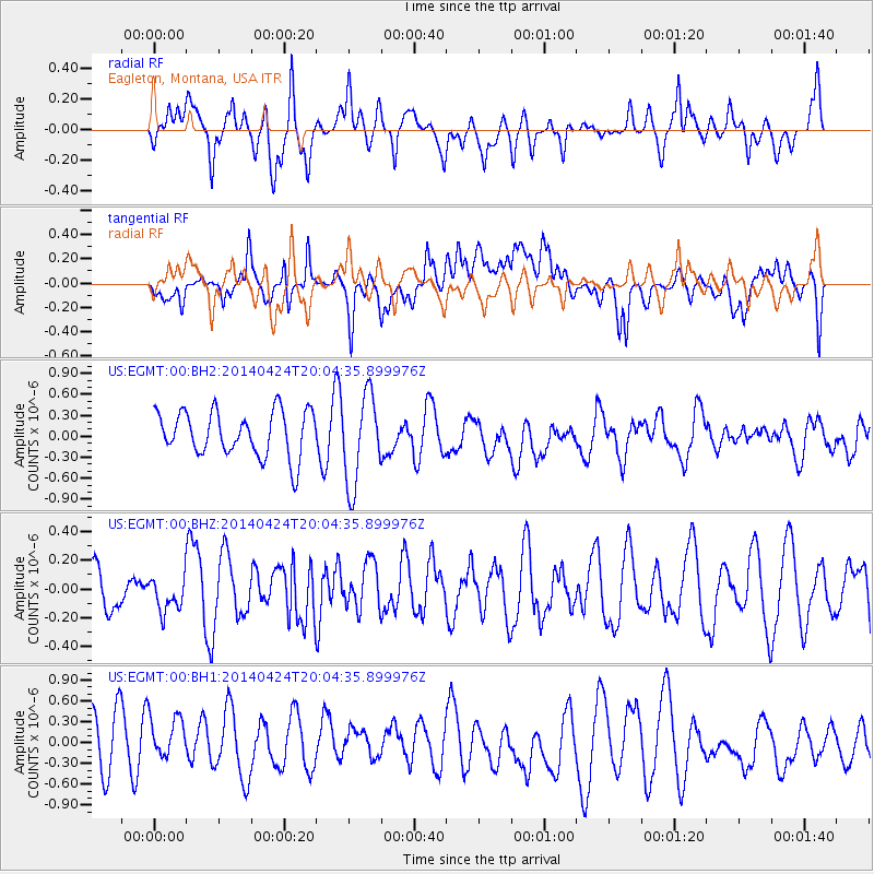
EGMT Eagleton, Montana, USA - Earthquake Result Viewer
*The percent match for this event was below the threshold and hence no stack was calculated.
| Earthquake location: |
South Of Fiji Islands |
| Earthquake latitude/longitude: |
-23.9/-176.7 |
| Earthquake time(UTC): |
2014/04/24 (114) 19:51:59 GMT |
| Earthquake Depth: |
66 km |
| Earthquake Magnitude: |
5.9 M |
| Earthquake Catalog/Contributor: |
NEIC PDE/NEIC ALERT |
|
| Network: |
US United States National Seismic Network |
| Station: |
EGMT Eagleton, Montana, USA |
| Lat/Lon: |
48.02 N/109.75 W |
| Elevation: |
1055 m |
|
| Distance: |
93.4 deg |
| Az: |
38.239 deg |
| Baz: |
237.518 deg |
| Ray Param: |
$rayparam |
*The percent match for this event was below the threshold and hence was not used in the summary stack. |
|
| Radial Match: |
62.617977 % |
| Radial Bump: |
400 |
| Transverse Match: |
41.42173 % |
| Transverse Bump: |
400 |
| SOD ConfigId: |
626651 |
| Insert Time: |
2014-05-08 20:28:20.373 +0000 |
| GWidth: |
2.5 |
| Max Bumps: |
400 |
| Tol: |
0.001 |
|
Signal To Noise
| Channel | StoN | STA | LTA |
| US:EGMT:00:BHZ:20140424T20:04:35.899976Z | 0.7282097 | 1.1817404E-7 | 1.6228023E-7 |
| US:EGMT:00:BH1:20140424T20:04:35.899976Z | 1.0293816 | 4.869405E-7 | 4.7304175E-7 |
| US:EGMT:00:BH2:20140424T20:04:35.899976Z | 2.0214982 | 6.4795853E-7 | 3.2053381E-7 |
| Arrivals |
| Ps | |
| PpPs | |
| PsPs/PpSs | |


