You are here: Home > Network List > YT07 - POLENET Stations List
> Station SURP SURP > Earthquake Result Viewer
SURP SURP - Earthquake Result Viewer
| Earthquake location: |
South Sandwich Islands Region |
| Earthquake latitude/longitude: |
-55.5/-28.2 |
| Earthquake time(UTC): |
2015/02/16 (047) 22:00:53 GMT |
| Earthquake Depth: |
10 km |
| Earthquake Magnitude: |
6.2 MWW, 6.7 MI |
| Earthquake Catalog/Contributor: |
NEIC PDE/NEIC COMCAT |
|
| Network: |
YT POLENET |
| Station: |
SURP SURP |
| Lat/Lon: |
84.72 S/171.20 W |
| Elevation: |
407 m |
|
| Distance: |
39.0 deg |
| Az: |
185.086 deg |
| Baz: |
147.034 deg |
| Ray Param: |
0.07523156 |
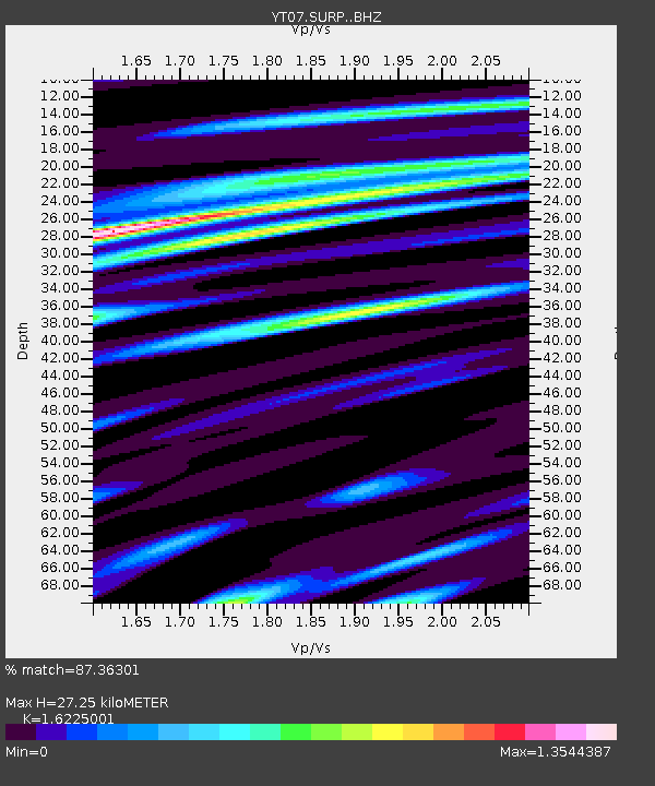
| Estimated Moho Depth: |
27.25 km |
| Estimated Crust Vp/Vs: |
1.62 |
| Assumed Crust Vp: |
6.245 km/s |
| Estimated Crust Vs: |
3.849 km/s |
| Estimated Crust Poisson's Ratio: |
0.19 |
|
| Radial Match: |
87.36301 % |
| Radial Bump: |
400 |
| Transverse Match: |
72.438255 % |
| Transverse Bump: |
400 |
| SOD ConfigId: |
7019011 |
| Insert Time: |
2019-04-16 20:42:27.181 +0000 |
| GWidth: |
2.5 |
| Max Bumps: |
400 |
| Tol: |
0.001 |
|

Signal To Noise
| Channel | StoN | STA | LTA |
| YT:SURP: :BHZ:20150216T22:07:48.949001Z | 3.9509094 | 1.0299384E-6 | 2.606839E-7 |
| YT:SURP: :BHN:20150216T22:07:48.949001Z | 3.2245076 | 4.3616592E-7 | 1.352659E-7 |
| YT:SURP: :BHE:20150216T22:07:48.949001Z | 3.0003936 | 4.5416348E-7 | 1.5136796E-7 |
| Arrivals |
| Ps | 2.9 SECOND |
| PpPs | 11 SECOND |
| PsPs/PpSs | 14 SECOND |


