You are here: Home > Network List > YQ13 - Study of Extension and Magmatism in Malawi and Tanzania Stations List
> Station BUMI Ibumi,Tanzania > Earthquake Result Viewer
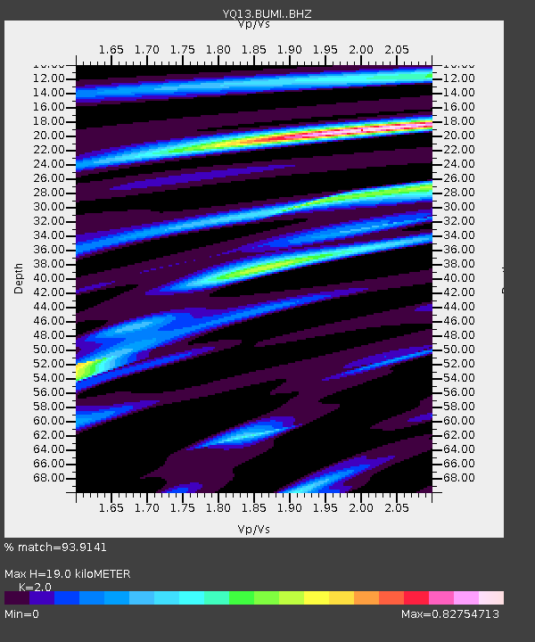
BUMI Ibumi,Tanzania - Earthquake Result Viewer
| Earthquake location: |
South Sandwich Islands Region |
| Earthquake latitude/longitude: |
-55.5/-28.2 |
| Earthquake time(UTC): |
2015/02/16 (047) 22:00:53 GMT |
| Earthquake Depth: |
10 km |
| Earthquake Magnitude: |
6.2 MWW, 6.7 MI |
| Earthquake Catalog/Contributor: |
NEIC PDE/NEIC COMCAT |
|
| Network: |
YQ Study of Extension and Magmatism in Malawi and Tanzania |
| Station: |
BUMI Ibumi,Tanzania |
| Lat/Lon: |
10.13 S/34.94 E |
| Elevation: |
1333 m |
|
| Distance: |
66.7 deg |
| Az: |
73.151 deg |
| Baz: |
213.551 deg |
| Ray Param: |
0.05747438 |
| Estimated Moho Depth: |
19.0 km |
| Estimated Crust Vp/Vs: |
2.00 |
| Assumed Crust Vp: |
6.502 km/s |
| Estimated Crust Vs: |
3.251 km/s |
| Estimated Crust Poisson's Ratio: |
0.33 |
|
| Radial Match: |
93.9141 % |
| Radial Bump: |
400 |
| Transverse Match: |
75.08878 % |
| Transverse Bump: |
400 |
| SOD ConfigId: |
7019011 |
| Insert Time: |
2019-04-16 20:42:33.057 +0000 |
| GWidth: |
2.5 |
| Max Bumps: |
400 |
| Tol: |
0.001 |
|

Signal To Noise
| Channel | StoN | STA | LTA |
| YQ:BUMI: :BHZ:20150216T22:11:12.54501Z | 8.580307 | 7.844989E-7 | 9.143017E-8 |
| YQ:BUMI: :BHN:20150216T22:11:12.54501Z | 2.7416852 | 3.0065718E-7 | 1.0966146E-7 |
| YQ:BUMI: :BHE:20150216T22:11:12.54501Z | 2.6698554 | 2.2857222E-7 | 8.5612214E-8 |
| Arrivals |
| Ps | 3.0 SECOND |
| PpPs | 8.5 SECOND |
| PsPs/PpSs | 11 SECOND |


