You are here: Home > Network List > YQ13 - Study of Extension and Magmatism in Malawi and Tanzania Stations List
> Station ILIN Ilindi,Tanzania > Earthquake Result Viewer
ILIN Ilindi,Tanzania - Earthquake Result Viewer
| Earthquake location: |
South Sandwich Islands Region |
| Earthquake latitude/longitude: |
-55.5/-28.2 |
| Earthquake time(UTC): |
2015/02/16 (047) 22:00:53 GMT |
| Earthquake Depth: |
10 km |
| Earthquake Magnitude: |
6.2 MWW, 6.7 MI |
| Earthquake Catalog/Contributor: |
NEIC PDE/NEIC COMCAT |
|
| Network: |
YQ Study of Extension and Magmatism in Malawi and Tanzania |
| Station: |
ILIN Ilindi,Tanzania |
| Lat/Lon: |
9.08 S/33.33 E |
| Elevation: |
1919 m |
|
| Distance: |
66.7 deg |
| Az: |
71.09 deg |
| Baz: |
213.0 deg |
| Ray Param: |
0.05747369 |
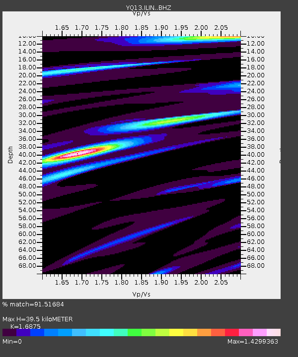
| Estimated Moho Depth: |
39.5 km |
| Estimated Crust Vp/Vs: |
1.69 |
| Assumed Crust Vp: |
6.502 km/s |
| Estimated Crust Vs: |
3.853 km/s |
| Estimated Crust Poisson's Ratio: |
0.23 |
|
| Radial Match: |
91.51684 % |
| Radial Bump: |
400 |
| Transverse Match: |
60.013462 % |
| Transverse Bump: |
400 |
| SOD ConfigId: |
7019011 |
| Insert Time: |
2019-04-16 20:42:38.137 +0000 |
| GWidth: |
2.5 |
| Max Bumps: |
400 |
| Tol: |
0.001 |
|

Signal To Noise
| Channel | StoN | STA | LTA |
| YQ:ILIN: :BHZ:20150216T22:11:12.54501Z | 9.310848 | 7.3298077E-7 | 7.872331E-8 |
| YQ:ILIN: :BHN:20150216T22:11:12.54501Z | 2.4964807 | 3.3970414E-7 | 1.360732E-7 |
| YQ:ILIN: :BHE:20150216T22:11:12.54501Z | 1.3985187 | 1.883185E-7 | 1.3465568E-7 |
| Arrivals |
| Ps | 4.4 SECOND |
| PpPs | 16 SECOND |
| PsPs/PpSs | 20 SECOND |


