You are here: Home > Network List > YQ13 - Study of Extension and Magmatism in Malawi and Tanzania Stations List
> Station KARM Karonga Airport MW > Earthquake Result Viewer
KARM Karonga Airport MW - Earthquake Result Viewer
| Earthquake location: |
South Sandwich Islands Region |
| Earthquake latitude/longitude: |
-55.5/-28.2 |
| Earthquake time(UTC): |
2015/02/16 (047) 22:00:53 GMT |
| Earthquake Depth: |
10 km |
| Earthquake Magnitude: |
6.2 MWW, 6.7 MI |
| Earthquake Catalog/Contributor: |
NEIC PDE/NEIC COMCAT |
|
| Network: |
YQ Study of Extension and Magmatism in Malawi and Tanzania |
| Station: |
KARM Karonga Airport MW |
| Lat/Lon: |
9.95 S/33.90 E |
| Elevation: |
527 m |
|
| Distance: |
66.2 deg |
| Az: |
72.114 deg |
| Baz: |
213.317 deg |
| Ray Param: |
0.05775173 |
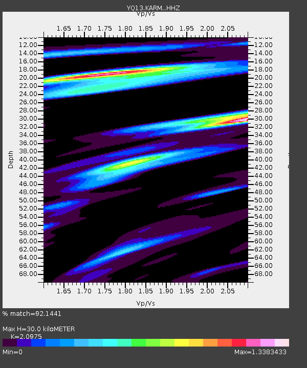
| Estimated Moho Depth: |
30.0 km |
| Estimated Crust Vp/Vs: |
2.10 |
| Assumed Crust Vp: |
6.502 km/s |
| Estimated Crust Vs: |
3.1 km/s |
| Estimated Crust Poisson's Ratio: |
0.35 |
|
| Radial Match: |
92.1441 % |
| Radial Bump: |
400 |
| Transverse Match: |
72.69758 % |
| Transverse Bump: |
400 |
| SOD ConfigId: |
7019011 |
| Insert Time: |
2019-04-16 20:42:43.883 +0000 |
| GWidth: |
2.5 |
| Max Bumps: |
400 |
| Tol: |
0.001 |
|

Signal To Noise
| Channel | StoN | STA | LTA |
| YQ:KARM: :HHZ:20150216T22:11:09.855984Z | 8.712685 | 7.30535E-7 | 8.384729E-8 |
| YQ:KARM: :HHN:20150216T22:11:09.855984Z | 4.3121195 | 3.3650036E-7 | 7.803595E-8 |
| YQ:KARM: :HHE:20150216T22:11:09.855984Z | 1.2047473 | 1.3865237E-7 | 1.1508834E-7 |
| Arrivals |
| Ps | 5.2 SECOND |
| PpPs | 14 SECOND |
| PsPs/PpSs | 19 SECOND |


